
Day 6 of my daily creative challenge.
Today: Harmattan for aerial capture.
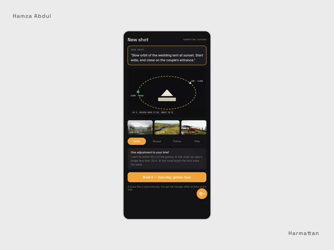
Most drone footage starts with a pilot you have to book, brief, and hope reads your mind. Here you just describe the shot: "slow orbit of the wedding tent at sunset, start wide, end close on the couple's entrance." The agent plans the flight, times it to golden hour, and a Scout flies it autonomously.
It's honest about its limits. It can't fly within 30m of guests, so it tells you upfront that the close-up will use a longer lens from farther out, where the shot looks the same. You book knowing exactly what you'll get. The same tool maps as well as it films. Describe a site, "the new estate off the Kachia road, for the planning application," and it returns an orthomosaic, an elevation model and a 3D model at survey accuracy.
The trust runs through the money too. If the weather stops the flight, you don't pay. Footage arrives colour-graded within the hour, yours outright, with a flight log proving every frame was shot inside the permissions.
This is a fictional product, designed end to end. Screens below.
I design interfaces for AI agents. If you're building one, my inbox is open.
#ProductDesign (https://www.linkedin.com/search/results/all/?keywords=%23productdesign&origin=HASH_TAG_FROM_FEED) #UX (https://www.linkedin.com/search/results/all/?keywords=%23ux&origin=HASH_TAG_FROM_FEED) #AIAgents (https://www.linkedin.com/search/results/all/?keywords=%23aiagents&origin=HASH_TAG_FROM_FEED) #Drones (https://www.linkedin.com/search/results/all/?keywords=%23drones&origin=HASH_TAG_FROM_FEED) #Cinematography (https://www.linkedin.com/search/results/all/?keywords=%23cinematography&origin=HASH_TAG_FROM_FEED)
1
103


Day 5 of my daily creative challenge.
Today: Harmattan for agriculture.
One of the ideas I have been incubating is how drones can be used to monitor farm produce and livestock. Not just to protect them from pest, predators and thieves, but also in detecting diseases and recommending solutions. Harmattan drones can be configured to detect changes in crops and animals, flag them, and provide suggestions on how to resolve them. In addition to this, the drones can be used to survey farmland and predict natural disasters like flooding and erosion using historical environmental data to help farmers observe safety precautions
0
81


