Geomockery: AI-Powered Geospatial Data Generator
Richard Donohue
🗺️ GEOMOCKERY
"Why wait for real data when you can generate better fake data?"
Geomockery is the AI-powered geospatial data generator that solves the eternal developer problem: "I need realistic location data... but I can't use the real stuff."
Built with modern web technologies and a brutalist design philosophy, Geomockery transforms the tedious process of creating test data into a fun, creative experience.
🚧 Development Status: Geomockery is currently in active development and approaching alpha release. Core features are functional, but expect some rough edges as we polish the experience. We welcome feedback and contributions!
🎯 About: Filling the Void in Geospatial Development
Every geospatial developer has been there:
🚧 The real data isn't ready yet (and it never will be on time)
🔒 Privacy concerns make real data off-limits for development
📊 Production data is too sensitive to use in testing environments
🎲 You need specific edge cases that don't exist in real datasets
🏗️ Client data is under NDA but you still need to build the app
Traditional solutions suck:
Generic placeholder data that doesn't reflect real-world complexity
Manually crafting test datasets (soul-crushing and time-consuming)
Using oversimplified geometric shapes that miss spatial relationships
CSV files with lat/lon columns that bear no resemblance to actual use cases
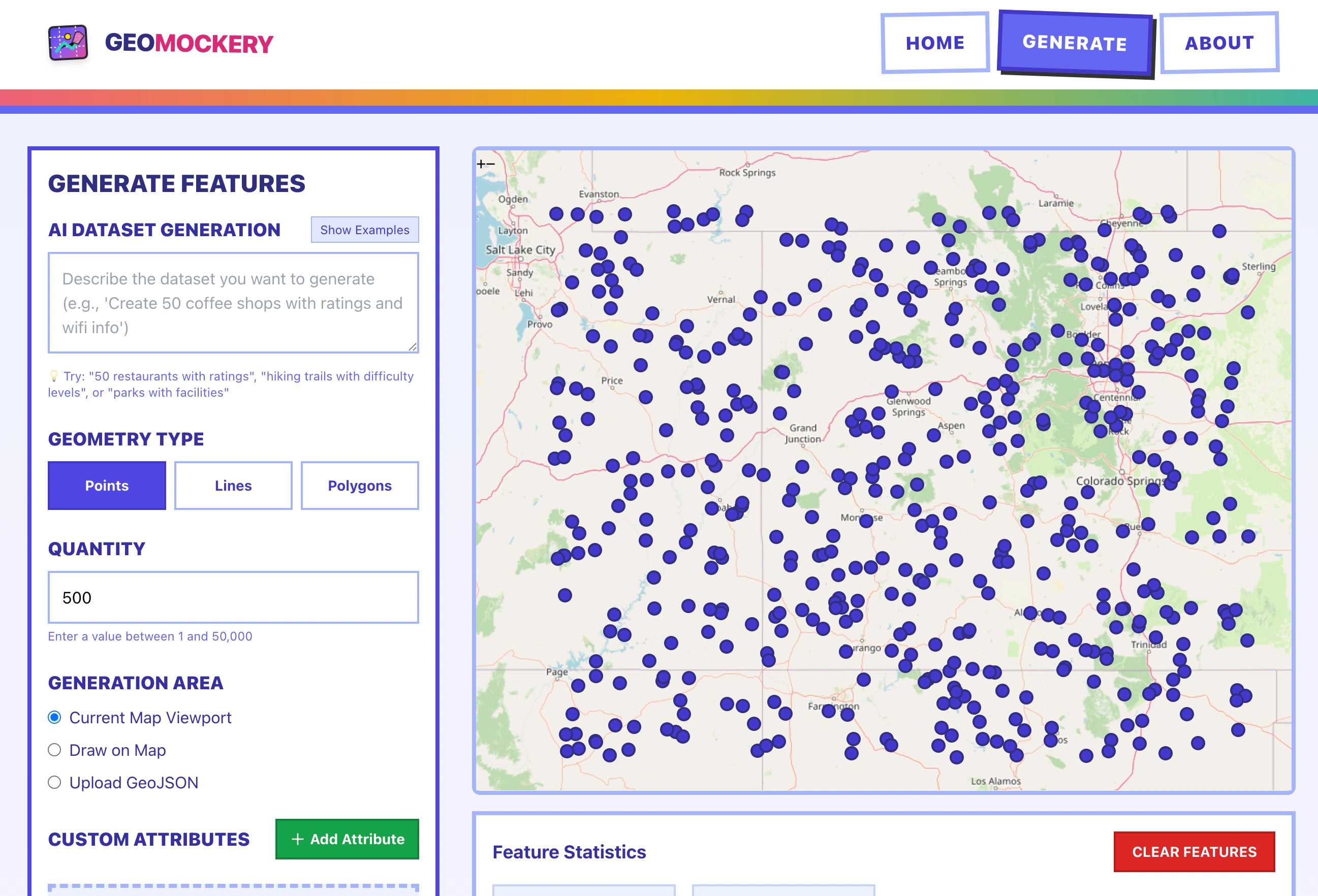
Geomockery changes the game by generating contextually-aware, realistic geospatial features that actually make sense together. Need 500 coffee shops distributed realistically across downtown? Done. Want delivery routes that follow actual street patterns? Easy. Need census tract polygons with correlated demographic attributes? You got it.
Why We Built This
The geospatial development ecosystem has amazing tools for working with location data, but creating realistic test data remained a massive pain point. We wanted to remove that friction entirely and make data generation as creative and intuitive as the apps we're building.
Geomockery fills this gap with:
Smart spatial distribution that mimics real-world patterns
AI-powered attribute generation that creates meaningful relationships
Privacy-safe development with zero real-world data exposure
Export flexibility that works with your existing GIS workflow
⚡ Features That Actually Matter
🎨 Creative Data Generation
Points, Lines & Polygons: Generate any geometry type with intelligent spatial relationships
AI-Powered Attributes: Custom schemas with contextually relevant values
Natural Distribution: Realistic clustering and spacing that mimics real data
Interactive Drawing: Define boundaries by sketching directly on the map
🛠️ Developer-Friendly Workflow
Multiple Export Formats: GeoJSON, Shapefile, GeoPackage - whatever your stack needs
Boundary Flexibility: Use map viewport, custom drawn areas, or upload existing GeoJSON
Attribute Customization: Nominal, ordinal, quantitative, temporal, and identifier types
Instant Preview: See your data before you download it
🚀 Performance & Scale
Client-Side Generation: No server dependency, works offline
Scalable Output: Generate 1 to 50,000+ features efficiently
Modern Stack: Built with Next.js 15, React 19, and clean project structure
🎮 Getting Started (It's Actually Fun)
Open http://localhost:3000 and start generating!
Quick Win Tutorial:
🗺️ Navigate to any area on the map
🎯 Choose "Points" and set quantity to 50
⚡ Click "Generate Features"
💾 Export as GeoJSON
🎉 Use in your app immediately
🧠 Smart Features
Attribute Intelligence
Geomockery doesn't just throw random values around. It understands context:
Nominal: Restaurant types, zoning categories, facility classifications
Ordinal: Priority levels (High/Medium/Low), quality ratings, size categories
Quantitative: Population counts, revenue figures, measurement values
Temporal: Operating hours, construction dates, event schedules
Identifiers: Permit numbers, asset IDs, reference codes
Spatial Awareness
Features are generated with realistic spatial relationships:
Points cluster near geographic features
Lines follow logical paths and connections
Polygons respect boundaries and avoid overlap conflicts
Attributes correlate with spatial context
🏗️ Architecture
Geomockery is organized with a clean, maintainable structure:
Tech Stack:
Frontend: Next.js 15, React 19, TailwindCSS
Mapping: OpenLayers for visualization and interaction
Geospatial: Turf.js for spatial operations and analysis
Design: Custom brutalist design system
Export: Support for all major geospatial formats
🔮 Coming Soon
🤖 Natural Language Generation: "Generate 100 coffee shops in Manhattan"
📡 API Access: Programmatic generation for CI/CD pipelines
🗄️ Raster Data: Elevation models, land cover, and imagery
📊 Advanced Statistics: Custom probability distributions
🔄 Batch Operations: Generate multiple datasets simultaneously
🤝 Collaboration: Share and remix generation templates
🤝 Join the Movement
Geomockery is open source and built by developers, for developers. We believe that creating test data should be creative, not painful.
Ways to contribute:
🐛 Report Issues: Found a bug? Let us know!
💡 Feature Ideas: What would make your workflow better?
🛠️ Code Contributions: PRs welcome for features and fixes
📖 Documentation: Help others discover the power of generated data
⭐ Star the Project: Show your support and help others find it
📜 License
MIT License - Build amazing things with it!
🙌 Credits
Built with passion by developers who got tired of waiting for "real" data to become available. Special thanks to the open source geospatial community for providing the foundational tools that make Geomockery possible.
Made with boldness and a commitment to solving real problems. 🚀
"The best test data is the data you can generate exactly when you need it."
Like this project
Posted Aug 1, 2025
Geomockery is an AI-powered web application for generating realistic mock geospatial data for testing and development purposes.
Likes
0
Views
16
Timeline
May 1, 2025 - Jun 30, 2025