Projects using ArcGIS in Vienna
Projects using ArcGIS in Vienna
Sign Up
Post a job
Sign Up
Log In
Filters
2
Projects
People
Results that are similar to your search
Similar results
Message
1
Andi Ramdani
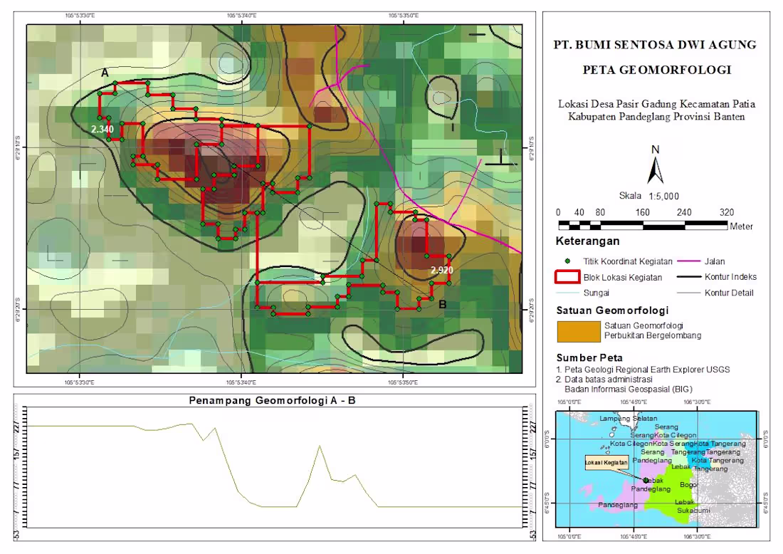
Geomorphological Mapping Project | GIS Analysis Just wrapped up a geomorphological mapping project for a site located in Pasir Gadung Village, Pandeglang, Banten. This work focuses on identifying landform characteristics and terrain variation to support better spatial understanding and decision-making. In this map, I combined elevation data, contour analysis, and spatial interpretation to classify geomorphological units—highlighting areas dominated by undulating hill formations. The red polygons represent the project activity zones, supported by coordinate points collected from the field. I also included a cross-section (A–B) to visualize terrain changes more clearly, giving a better perspective of slope variation and landform structure across the site. Tools & Approach: - GIS processing and spatial analysis - Contour and elevation modeling - Geomorphological interpretation - Map layout and visualization This kind of analysis is essential for projects related to land development, environmental assessment, and infrastructure planning. Always open to feedback and collaboration—let’s connect 🚀
1
138
Message
0
Sadaqat Ali
Designed and developed an interactive web visualization application featuring dynamic maps, data dashboards, and user-friendly analytics. The platform enables efficient exploration of complex data through responsive and visually engaging interfaces.
0
34
Message
0
Gabriel Homoky
AERIAL RENDERS - MANCHESTER AIRPORT HOTELS
0
52
Message
1
Sunbeam Rahman
Forest health assessment using GEOBIA
1
1
43
Message
1
HONGDAN CHEN
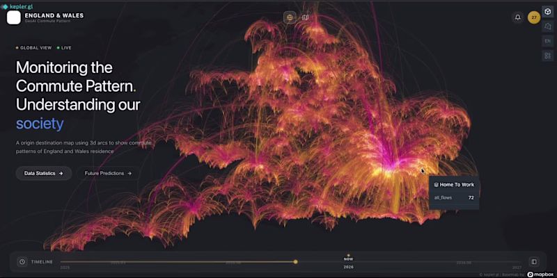
From static maps → interactive spatial experiences. 🚀 Recently experimented with building a Geo-inspired commute dashboard using Vibe Coding + geospatial visualization. The interesting shift for me: Instead of spending days moving between GIS software, frontend development, and UI iteration, ideas can become working interfaces much faster. Still early, but it opens up interesting possibilities: → spatial analytics that feel more accessible → interfaces ready for predictive layers and AI workflows → reducing the barrier between geographic data and end users Curious where GIS + AI + Vibe Coding goes next.
1
76
Message
0
Michael Jeffreys
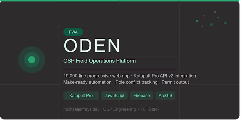
Fiber Optic Field Operations PWA (19,000 Lines)
0
1
Message
4
Andi Ramdani
Professional Geomorphology Map & Terrain Profile (ArcGIS/QGIS) I create precise and visually clear geomorphological maps like this, including: - Contour mapping (index & detailed) - Landform interpretation - River and infrastructure overlay - Project boundary mapping - Elevation cross-section analysis (A–B profile) Perfect for research, environmental analysis, mining, or land development projects.
5
4
185
Message
0
Sadaqat Ali
Created a 3D urban parking facility model for a city development project, showcasing efficient parking layouts, traffic circulation, and public accessibility. The visualization supported urban planning, infrastructure design, and decision-making processes.
0
36
Message
1
Sunbeam Rahman
Canopy crown indentification using LiDAR
1
8
Message
1
HONGDAN CHEN
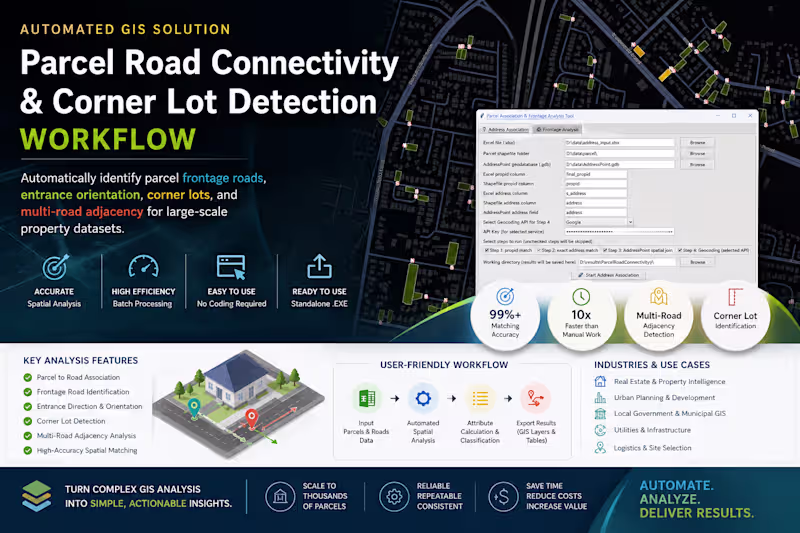
One of the most interesting shifts in AI right now: Real estate AI systems are only as smart as the spatial data behind them. Just wrapped up a GeoAI-oriented automation project for large-scale parcel intelligence in Australia. Built a standalone workflow that automatically detects: → frontage roads → corner lots → parcel orientation → multi-road adjacency → spatial access relationships The interesting part wasn’t the GIS itself. It was converting messy spatial relationships into structured knowledge that downstream AI systems can actually understand. A lot of “AI for real estate” conversations focus on LLMs. But the real bottleneck is often: How do you turn geography into machine-readable reasoning context? Ended up packaging the entire workflow into a production-ready executable app for non-technical teams, with batch processing + configurable spatial rules. Feels like we’re moving from: “mapping data” to “building spatial reasoning infrastructure.” #GeoAI #PropTech #SpatialComputing #Automation #GIS #AIInfrastructure
1
145
Message
0
Sadaqat Ali
Geospatial Analyst & 3D Modeling Specialist for Infrastructure, Mining & Urban Development
0
50
Message
1
HONGDAN CHEN
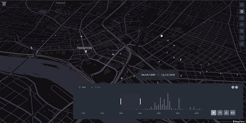
I create interactive 3D city visualizations showing how urban areas evolve over time. Using Kepler.gl (http://Kepler.gl), building footprint data is visualized in 3D with a time slider based on construction year, revealing the growth of a city. Each building is clickable and includes a direct link to street-level imagery in Google Street View, allowing users to explore the real-world view of the building. This visualization is ideal for urban planning, real estate analysis, city storytelling, and digital twin presentations.
1
160
Explore projects