The network for creativity
Join 1.25M professional creatives like you
Connect with clients, get discovered, and run your business 100% commission-free
Creatives on Contra have earned over $150M and we are just getting started
Back to feedPost
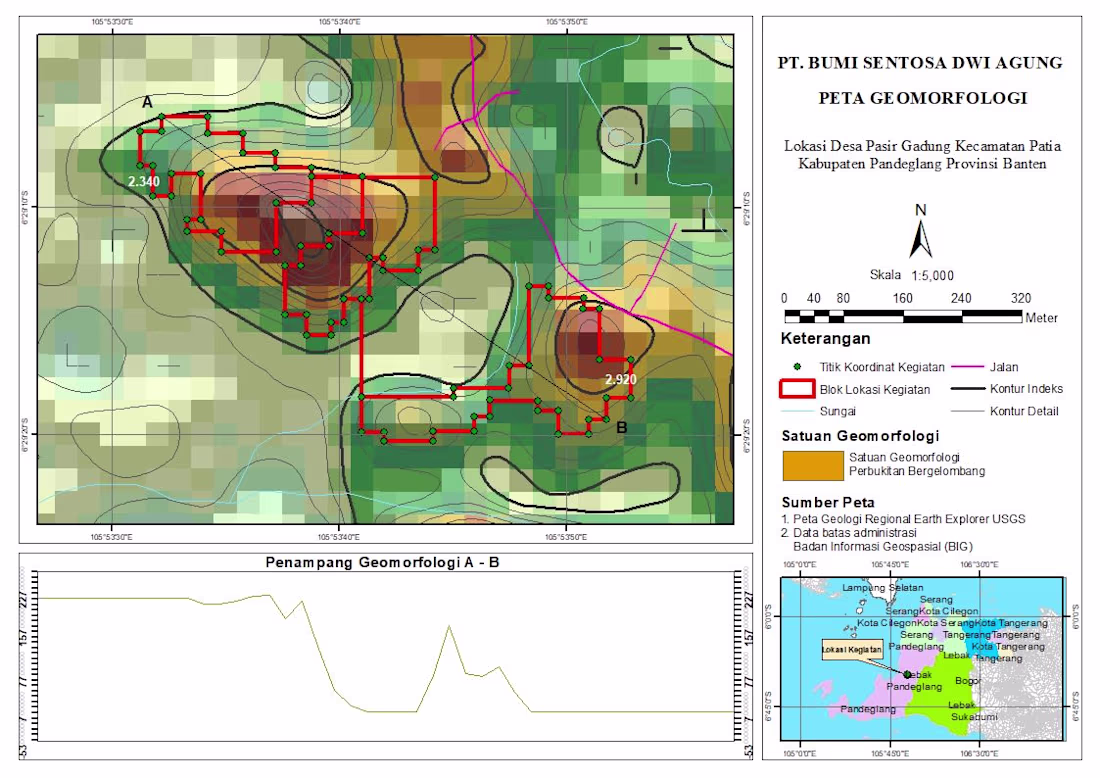
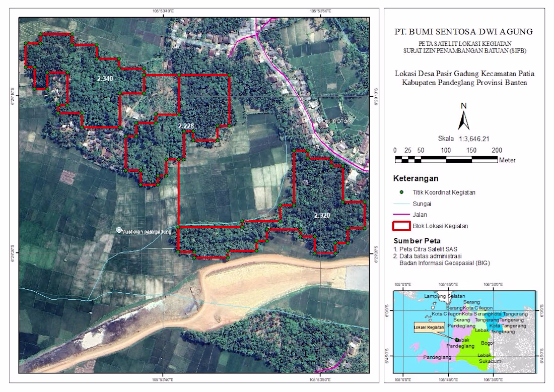
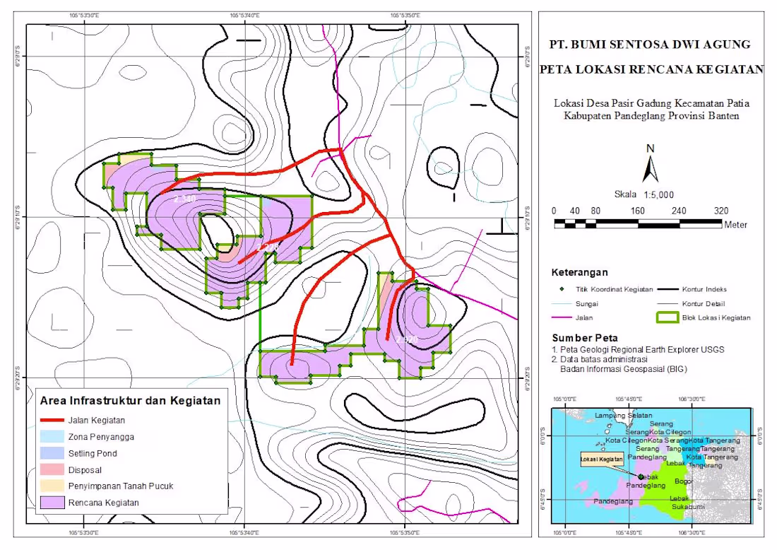
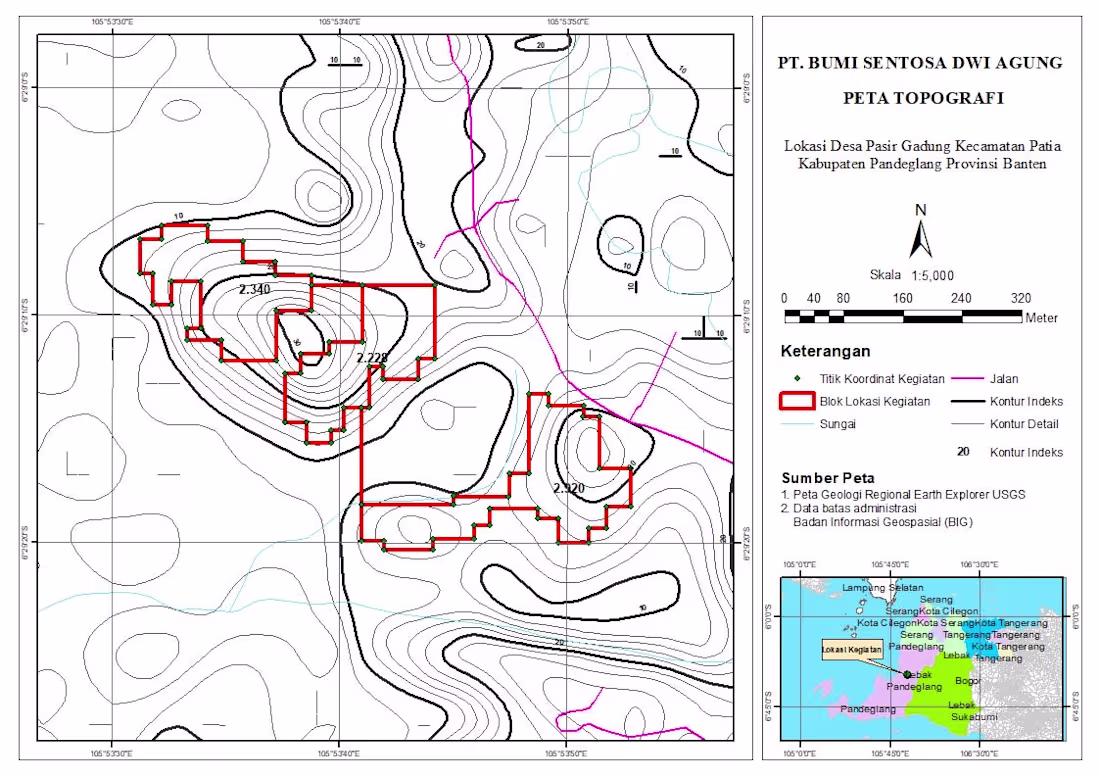
Geomorphological Mapping Project | GIS Analysis
Just wrapped up a geomorphological mapping project for a site located in Pasir Gadung Village, Pandeglang, Banten. This work focuses on identifying landform characteristics and terrain variation to support better spatial understanding and decision-making.
In this map, I combined elevation data, contour analysis, and spatial interpretation to classify geomorphological units—highlighting areas dominated by undulating hill formations. The red polygons represent the project activity zones, supported by coordinate points collected from the field.
I also included a cross-section (A–B) to visualize terrain changes more clearly, giving a better perspective of slope variation and landform structure across the site.
Tools & Approach:
- GIS processing and spatial analysis
- Contour and elevation modeling
- Geomorphological interpretation
- Map layout and visualization
This kind of analysis is essential for projects related to land development, environmental assessment, and infrastructure planning.
Always open to feedback and collaboration—let’s connect 🚀
The network for creativity
Join 1.25M professional creatives like you
Connect with clients, get discovered, and run your business 100% commission-free
Creatives on Contra have earned over $150M and we are just getting started
Trending
Claude
Claude has entered the design space. How are you using it?
Contra University
Learn from expert creatives how to earn more using next-gen AI tools.
Brand Design
The best brand designers are on Contra. Scroll to see what's trending in brand design. What are you building?
creativeaiflow
Creative AI workflows are evolving. What tools do you use, and what are their strengths and weaknesses?
freelancerlife
Freelancer life is wins, pivots, and everything in between. What’s yours right now?
Related posts
Project programmer, design application with high quality professional🚀🤩
Follow Snap, explain the design🥰
Turning "Where Is It?" Into the Best Page on the Site — 3D Mapbox Experience for an Austrian Alps Studio
A custom-built 3D interactive map experience for Wilderness Studios, a recording & event studio in the Austrian Alps. Built on Mapbox GL + @Webflow CMS: animated terrain, a drawn arrival route, live travel directions, and 96 curated points of interest — all editable by the client.
What I built
A full-screen, cinematic 3D map page that replaces the usual "Location & Contact" section — one continuous experience with two modes: The Location and The Surroundings.
1. Cinematic 3D terrain
Mapbox GL JS with custom dark terrain styling, exaggerated elevation and a hand-tuned camera. The page opens on a wide alpine shot with the studio marker sitting in the valley — the mountains do the storytelling before a single line of copy is read.
2. Animated arrival route
Instead of listing distances, the route draws itself across the terrain from the nearest town to the studio, with the camera flying along it. Every marker, label and stat fades in on its own timeline, so the whole intro reads as one choreographed shot rather than a map that happens to load.
3. Live directions panel
Airports, train stations and motorway exits with distances and drive times, each one selectable — pick Innsbruck Airport and the map re-frames to that leg of the journey. "Get Directions" hands off to native maps for the actual trip.
Stack
Webflow (structure + CMS) · Mapbox GL JS (3D terrain, custom style, markers, route layers) · GSAP (camera choreography, sequenced reveals) · vanilla JS (CMS → GeoJSON pipeline, category filtering, gallery, state between the two modes)
"This is a fantastic take on a location page. Turning directions into an immersive 3D experience makes the journey part of the brand story rather than just a utility. The combination of Mapbox, GSAP, and a CMS-driven approach creates something that's both visually impressive and genuinely useful.
🚦 Design isn't just about making something look good, it's about making information memorable.
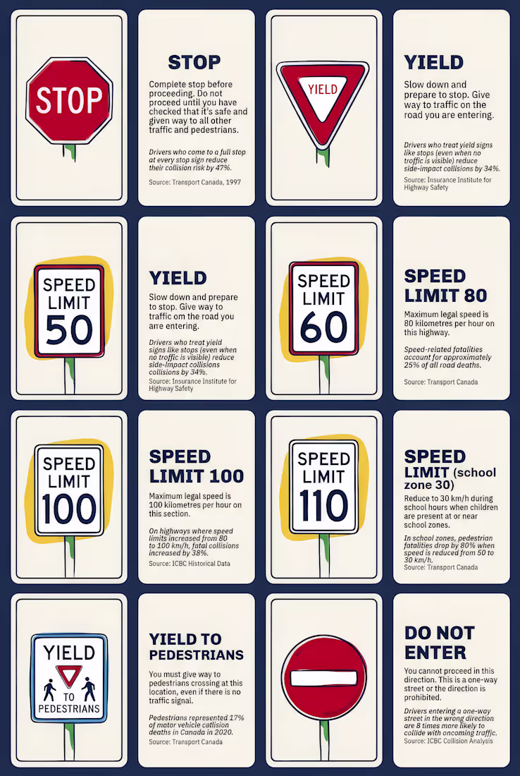
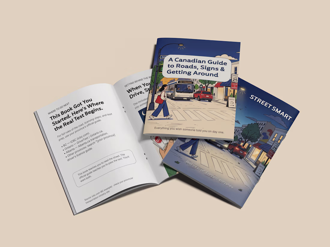
For this self-initiated concept, I wanted to rethink how road safety information could be experienced. Instead of another government-style pamphlet that people often ignore, I designed "Signs of Life"—a visual road safety handbook supported by a collection of interactive sign cards that make learning feel approachable and engaging.
The idea began with one question:
How can I make people actually want to read road safety information?
Rather than relying on fear-based messaging, I explored a friendlier educational approach inspired by editorial design, illustrations, and interactive learning. The goal was to help new drivers, newcomers to Canada, and everyday commuters understand road rules through simple visuals and clear storytelling.
My Process
• Researched Canadian road safety communication and identified opportunities to improve engagement.
• Developed the overall campaign concept and visual direction.
• Explored multiple layout systems before deciding on a handbook format that felt approachable instead of instructional.
• Designed custom editorial illustrations for each topic to make complex rules easier to understand.
• Created a consistent colour palette inspired by official Canadian road signs while maintaining a warm editorial aesthetic.
Key Design Decisions:
One of the biggest decisions was choosing clarity over decoration.
Although more playful concepts were explored during the early stages, I intentionally kept every road sign visually accurate so the information remained trustworthy and educational. The personality comes from the illustrations, layout, and storytelling—not by changing the actual road signs.
To make the experience more interactive, I also designed a series of Sign Cards that work as quick learning tools. Instead of reading long paragraphs, users can review important road signs, reinforce their knowledge, and build better driving habits in a simple, visual way