GIS Expert

Prasad Pala

AutoCAD, ArcGIS Desktop
ArcGIS, ArcGIS Pro, MicroStation, Excel
Power Point Presentation, Electrical design And Drafting Engineer,
REVIT MEP
Qgis
Downloading/Pre-processing of Satellite Images
Land-use/Land-cover Extraction
Drainage Analysis
Digitization of data base mapping
Routing/ Network Analysis
Geo processing tasks and automation
Geo database Design and Management
Plot creation and export
Catchment Area Analysis
Geo-referencing of Map & Contours
Format conversions (Transformation of data from PDF, arcGIS and auto-CAD, SHP to GDB etc..)
Merge multiple data into one master file
Scan/PDF to Excel conversion
Like this project


Geo Referencing
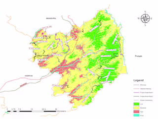
FLOOD SUSCEPTIBILITY MAPPING