The network for creativity
Join 1.25M professional creatives like you
Connect with clients, get discovered, and run your business 100% commission-free
Creatives on Contra have earned over $150M and we are just getting started
Back to feedPost
3D Terrain & Relief Mapping — Germany Regional Topography
Challenge:
Develop a high-fidelity, geographically accurate series of 3D topographic terrain models for the federal states of Germany. The primary goal was to transform complex GIS elevation data into premium visual assets optimized for infrastructure planning and executive corporate presentations.
Process & Execution:
1) Processing and texturing real-world GIS elevation datasets and satellite imagery.
2) High-resolution 3D displacement modeling to capture intricate land relief, mountain ranges, and vegetation structures.
3) Optimizing dense landscape geometry for clean presentation, digital architectural integration, and multi-scale usability.
Results:
Premium 3D geographic assets and high-end technical graphics tailored for logistics hubs, infrastructure developers, and corporate spatial analytics platforms.


Fantastic execution on these complex geographic assets! The 3D displacement mesh density and technical landscape clarity are absolutely top-notch. Brilliant work, Slava!

Thank you, Lara, for your high praise of my work.
The network for creativity
Join 1.25M professional creatives like you
Connect with clients, get discovered, and run your business 100% commission-free
Creatives on Contra have earned over $150M and we are just getting started



Related posts

The fix for an agent that keeps getting your design system wrong isn't a better prompt.
It's putting the rules where the agent reads them.
In the repo. In skills. In checks it can run itself.
Writing a course about exactly this.

How do you handle a component that needs an intentional exception? I'd want that exception scoped to the component, so the agent doesn't start using it across the app.

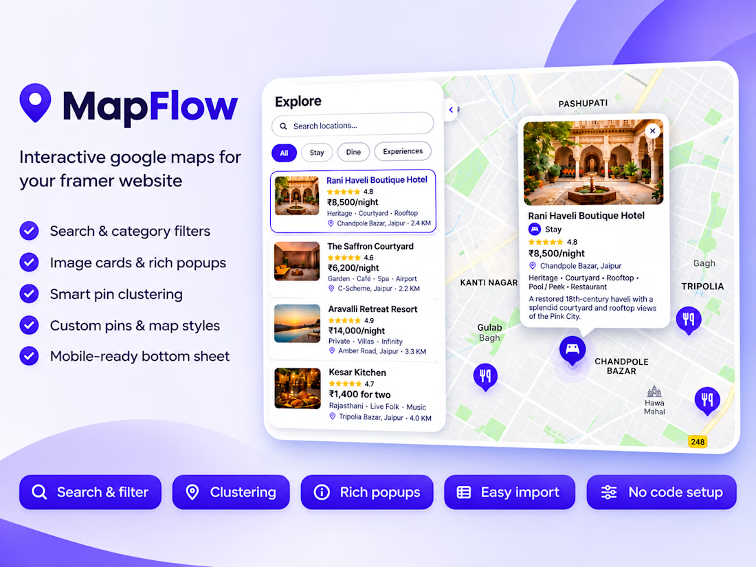
Introducing MapFlow 2.0: map, sidebar and popups in one Framer component
MapFlow 2.0 is a custom Google Maps component for Framer. Add locations with images, ratings, prices and details, then show them with category filters, search, clustering and polished popups. Everything is set from the property panel, no code.
Built for Framer, fully controlled from the property panel.
What’s new in 2.0
Sidebar with Image Cards or Category List. Show locations as image cards with rating, price and address, or as a clean drill-down list by category.
Search and category filters. Visitors search by name and filter with pills; the map reframes to match.
Rich popups. Image, category badge, star rating, price, address, details and a call-to-action button, each one toggled on or off.
Standard or Group markers. Use plain markers for a simple map, or group locations into categories with their own pin style and color.
Primary Location. Highlight your HQ, store or event venue with its own star pin and popup.
Smart clustering. Dense areas collapse into clean bubbles and expand as you zoom.
Auto distance. Show how far each place is from your primary location.
Bulk import. Paste a JSON or CSV list and add dozens of locations at once.
Easy coordinates. Type decimal degrees or degrees and minutes (21° 36' N).
Mobile-ready. On small screens the sidebar becomes a bottom sheet.
Full styling control. Map presets (Silver, Minimal, Grayscale, Night, Retro), custom JSON styles, native font controls, colors, radius and more.
Great for
Travel guides, real estate listings, restaurant and store locators, coworking and healthcare directories, event maps and city guides.
Demo data
The preview uses a fictional Jaipur City Guide (hotels, restaurants and experiences) to show every feature.
How to use it
- Drop MapFlow onto your canvas.
- Add your Google Maps API key.
- Add locations or paste an import list.
- Pick a sidebar layout and style it.



Testing designs for a Gran Reserva wine label that needs to feel traditional, sober, and confident. I chose a design with minimal ornamentation, where information hierarchy plays a key role in a clean layout.
Which of the two do you think reads better?
13 voted
43%
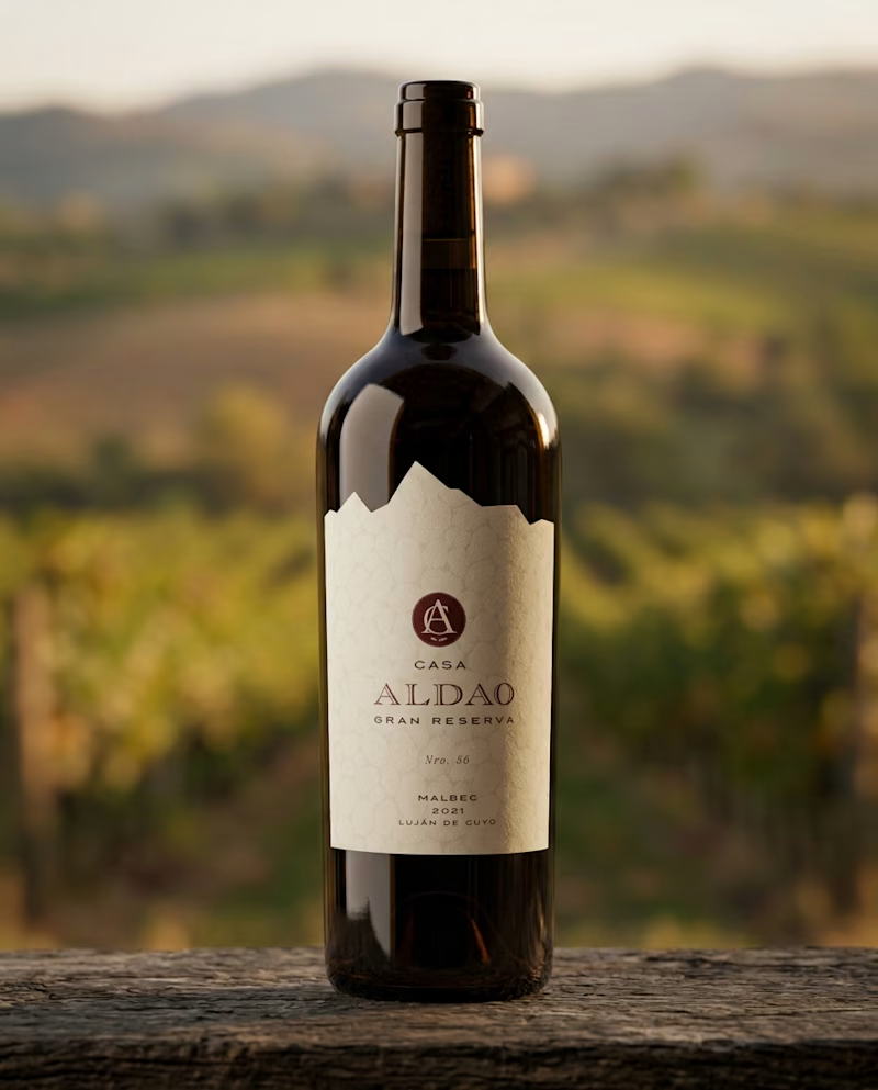
17 voted
57%
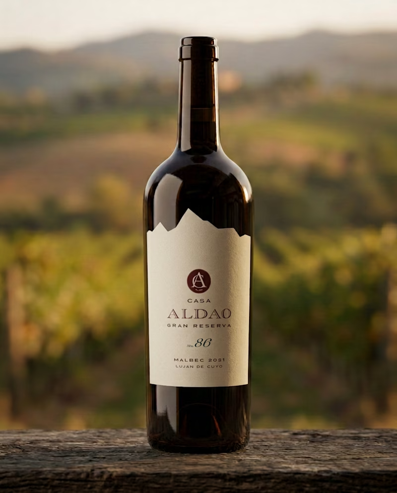
30 votes
Closed

Hola Luci! Cómo estás? Soy Argentina también!
De que provincia es el vino? Me encargo de las redes de una vinoteca en mi ciudad, y me llamó la atención. Tenemos cata este finde, y me gustaría proponer esta opción.