The network for creativity
Join 1.25M professional creatives like you
Connect with clients, get discovered, and run your business 100% commission-free
Creatives on Contra have earned over $150M and we are just getting started
Back to feedPost
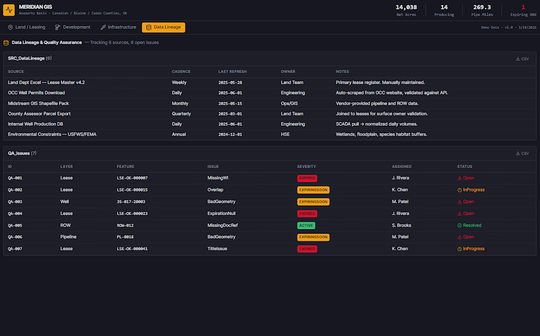
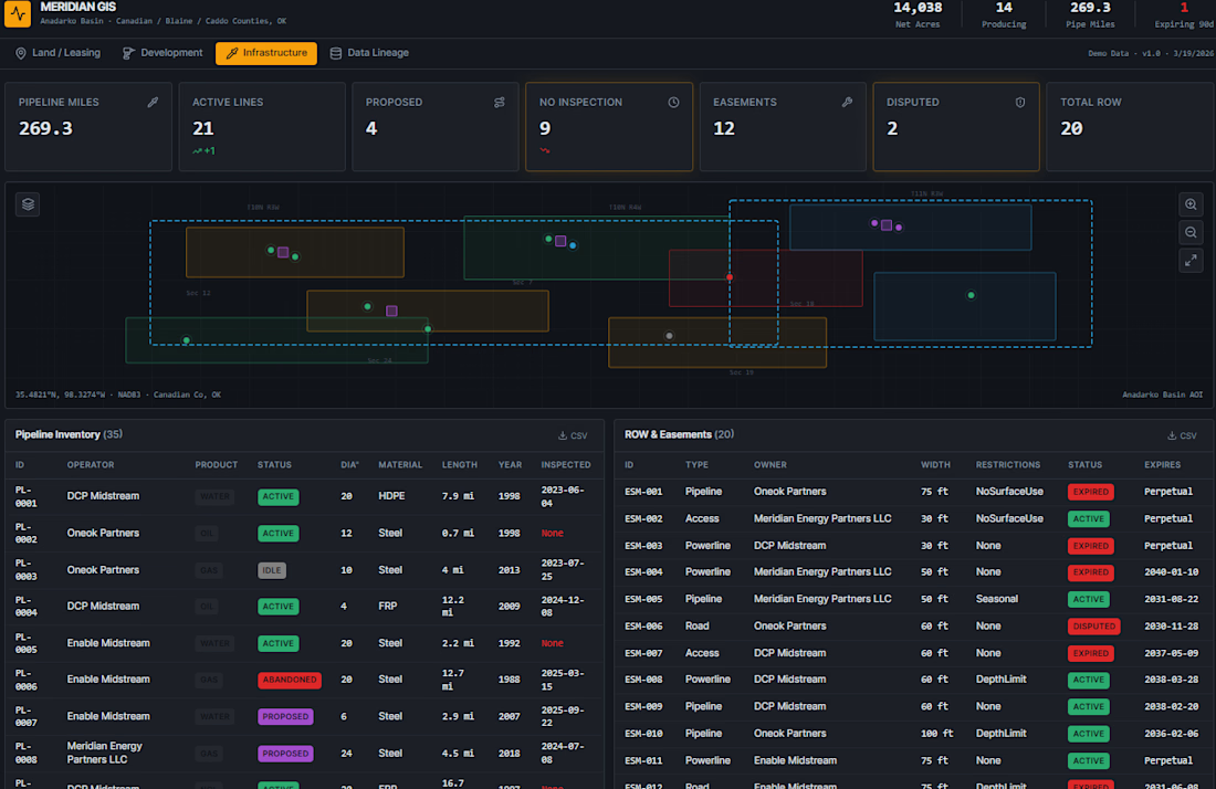
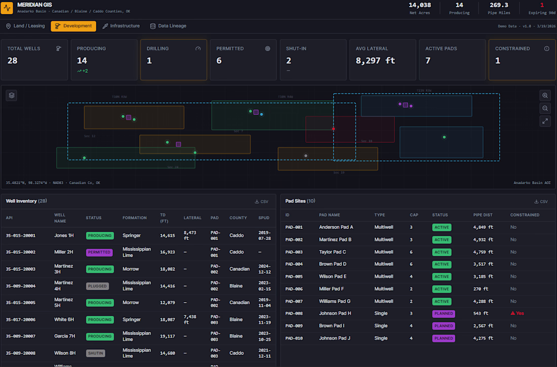
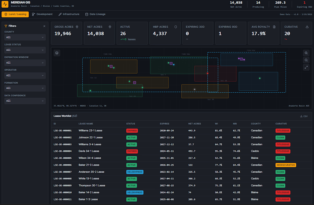
Lead the planning and development of a full-stack geospatial dashboard for upstream oil & gas operations in the Anadarko Basin (Oklahoma). It consolidates lease management, well development planning, pipeline/ROW infrastructure, and data quality tracking into a single decision-support tool, replacing scattered Excel sheets, PDFs, and disconnected GIS layers.
Who It Solves Problems For:
Land Teams — track lease expirations, HBP status, curative issues, and WI/NRI across hundreds of tracts
Development Engineers — plan pad sites, visualize SHL/BHL well paths, and assess DSU coverage
Operations / Midstream — monitor pipeline inventory, easement status, and ROW constraints
Management / A&D — executive KPIs, acreage-at-risk summaries, and portfolio-level confidence scoring
The network for creativity
Join 1.25M professional creatives like you
Connect with clients, get discovered, and run your business 100% commission-free
Creatives on Contra have earned over $150M and we are just getting started
Related posts
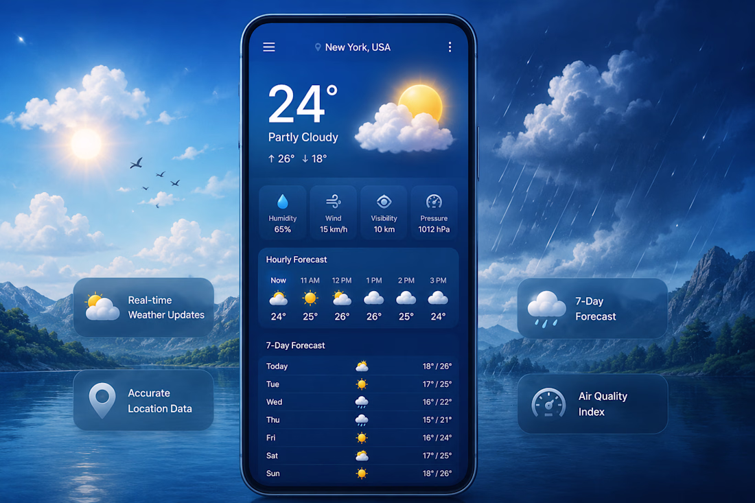
I built ClimateX — a real-time weather intelligence app with cinematic visuals, air quality monitoring, hourly & 7-day forecasts. It uses live API data and works beautifully on all devices.
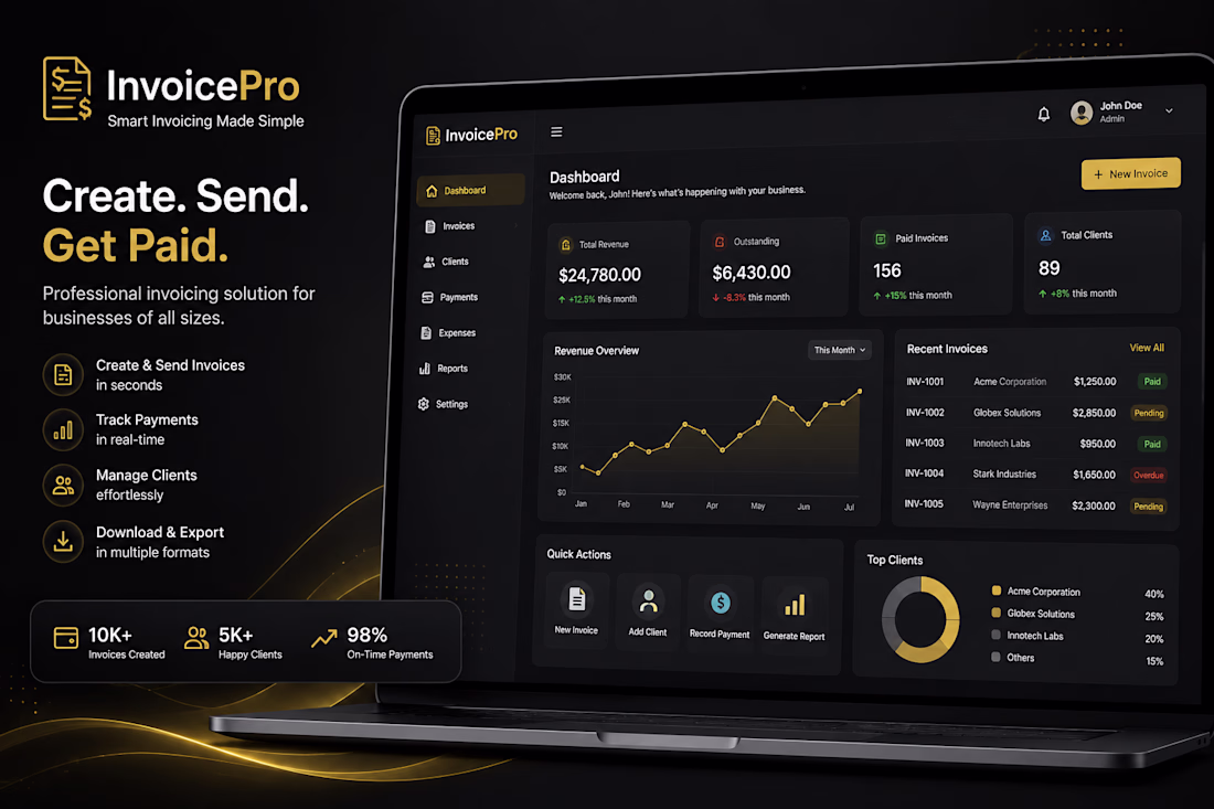
A full SaaS invoicing platform for freelancers & businesses. Features include invoice generation, client management, PDF export, payment tracking, analytics dashboard & multi-currency support.Trusted by 10,000+ businesses. Includes Free, Pro & Business pricing tiers with authentication system.
Please contact me before placing an order
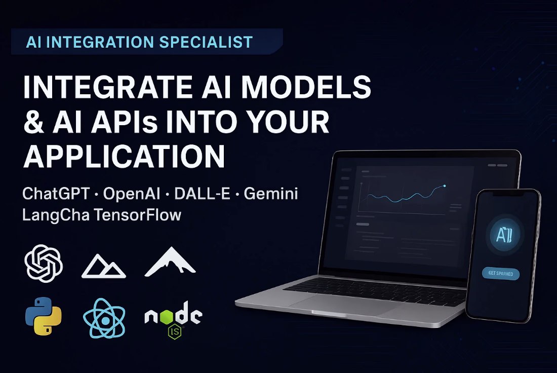
Do you want to supercharge your Application with powerful AI models or APIs? You're in the right place!
We specialize in integrating AI solutions like OpenAI (ChatGPT, GPT-4), TensorFlow, DALL-E, Gemini and more.
Whether you need AI-powered tools, recommendation systems, content editors, or intelligent assistants, we can bring them to life inside your application.
If you're not sure which AI model fits your needs best, no worries!
We'll help you choose the most efficient and cost-effective option, and once you're satisfied with the plan, we'll handle the complete development and integration.
TechStack:
Frontend/Framework: Vue.js, React.js, Nuxt.js, Next.js, Angular
AI Models: ChatGPT, Langchain, OpenAI (ChatGPT, GPT-4), TensorFlow, DALL-E, Gemini, and more
Backend/Frameworks: Node.js, Express.js, Nest.js, .NET Core, JAVA, Python
Database: MongoDB, Firebase, MySQL, PostgreSQL
Trending
Claude
Claude has entered the design space. How are you using Claude Design?
Contra University
Learn from expert creatives how to earn more using next-gen AI tools.
fifaworldcup2026
The World Cup is here and the whole world's watching. How are you designing for the world stage?
creativeaiflow
Creative AI workflows are evolving. What tools do you use, and what are their strengths and weaknesses?
freelancerlife
Freelancer life is wins, pivots, and everything in between. What’s yours right now?