Digitization Basis Data and Thematic Mapping Creation
Digitization Basis Data and Thematic Mapping Creation
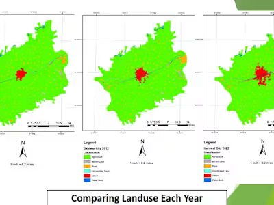
This project involves the digitization of satellite imagery to create shapefile data and thematic maps for the Detailed Spatial Planning Team (RDTR) of Mojowarno Subdistrict in Jombang Regency. The goal of the project is to support effective spatial planning by providing detailed and accurate land use and land cover data.
Project Description:
The project utilizes satellite imagery to digitize and create shapefiles representing different land use and land cover categories in Mojowarno Subdistrict. Thematic maps are generated to visualize these categories, which include residential areas, agricultural land, forests, and water bodies.
Objectives:
Digitization: Convert satellite imagery into shapefile data for detailed spatial analysis.
Thematic Mapping: Create thematic maps to visualize various land use and land cover categories.
Supporting Spatial Planning: Provide detailed land use data to assist in effective spatial planning and decision-making.
Methodology:
Data Collection: Gather satellite imagery and existing spatial data.
Digitization: Use GIS software to digitize land use categories and create shapefile data.
Mapping: Generate thematic maps to visualize the digitized data and present it in a user-friendly format.
Like this project
Posted Jun 14, 2024
This project involves the digitization of satellite imagery to create shapefile data and thematic maps for the Detailed Spatial Planning Team (RDTR) of Mojowarn
Likes
0
Views
0
Tags


