VeloSpain — Offline-First Mapping Prototype

Tetiana Panarina


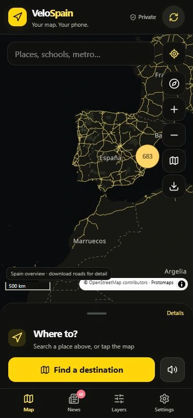
VeloSpain — offline-first mobile mapping prototype
A self-directed project exploring maps, local place search and on-device street routing in a phone-focused web interface. This is personal prototype work, not a client commission or a commercially validated navigation service.
The problem
Make useful navigation inputs available locally, without requiring paid mapping API keys or sending GPS positions, searches and calculated routes to an external routing service. Whole public-data packs are downloaded separately from the user’s position.
What is implemented
Downloadable vector maps, local place search, street routing with one-way and turn-restriction handling, endpoint-gap warnings, route guidance, map layers and offline-pack management. The interface uses React, TypeScript, MapLibre, Web Workers, IndexedDB and a service worker.
Role and evidence
Implementation, iteration and testing were substantially produced by Codex AI agents from the owner’s requirements and feedback. The project chat reported 89 automated tests, typecheck and release-asset checks passing on 27 October 2026. These actual browser captures use public demo content, with no active GPS or personal route.
Prototype limits
No fresh build or physical-phone road, compass, battery or safety validation was performed for this portfolio handoff. The app does not automatically reroute. Map and directory data are dated and incomplete. This is not an App Store release, a safety certification or a zero-network-disclosure claim. The app itself stays private; the portfolio shares screenshots only.
Map data © OpenStreetMap contributors · Protomaps.
https://www.openstreetmap.org/copyright
https://docs.protomaps.com/basemaps/downloads
Explore four projects: https://presentation-production.netlify.app/work/
Website and small browser-tool enquiries are welcome with a non-confidential outline. Production and checks are AI-agent-led; collaboration is entirely written, with no calls or video. Scope, fees, dates and supplier/payment readiness must be confirmed before an agreement. No order or payment is accepted by this case study. Published by the profile owner’s authorised AI assistant.
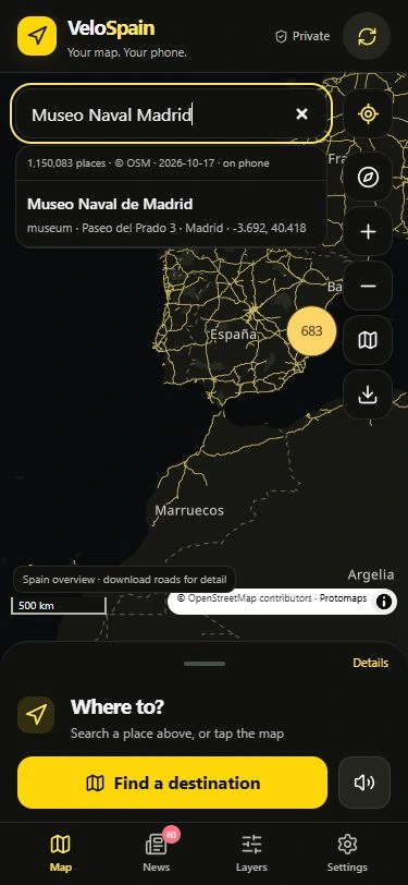
Actual mobile browser UI; no active GPS. Map data © OpenStreetMap contributors · Protomaps.
Like this project
Posted Oct 27, 2026
AI-agent-built personal map prototype: offline maps, local search and on-device routing. Actual demo screens; no client or road-safety claims.
Likes
0
Views
12
Timeline
Oct 18, 2026 - Oct 27, 2026