
Good reels are watched. Great ones are remembered. Most aren’t.
We recently collaborated with a creative agency that wanted to stand out for all the right reasons.
They needed social media reels that move — not just in frames, but in minds.
Using clean motion graphics, bold visuals, and storytelling designed to stop the scroll, we turned static posts into thumb-stopping brand moments.
Because in a world where audiences decide in 3 seconds or less, a forgettable reel is worse than no reel at all.
If you’re a creative business or agency ready to level up your brand story — let’s make it unforgettable.
hello@pictodesignstudio.com (mailto:hello@pictodesignstudio.com)
5
666







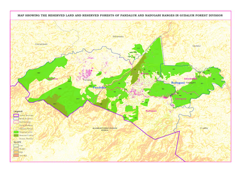
Reserved Land & Reserved Forest Map – Pandalur & Nadugani Ranges
This project focuses on mapping reserved lands and reserved forests in the Pandalur and Nadugani ranges under the Gudalur Forest Division.
Using QGIS, I created a detailed administrative map including division, range, beat, and survey boundaries. I integrated forest classification data with terrain (slope) analysis to provide a clear understanding of land distribution and landscape characteristics.
The map also highlights human settlements within and around forest areas, helping in planning, management, and decision-making.
This project demonstrates my expertise in administrative mapping, boundary digitization, and geospatial data visualization for government and environmental applications.
👉 Available for administrative mapping and GIS projects. Feel free to message me.
0
99


