The network for creativity
Join 1.25M professional creatives like you
Connect with clients, get discovered, and run your business 100% commission-free
Creatives on Contra have earned over $150M and we are just getting started
Back to feedPost

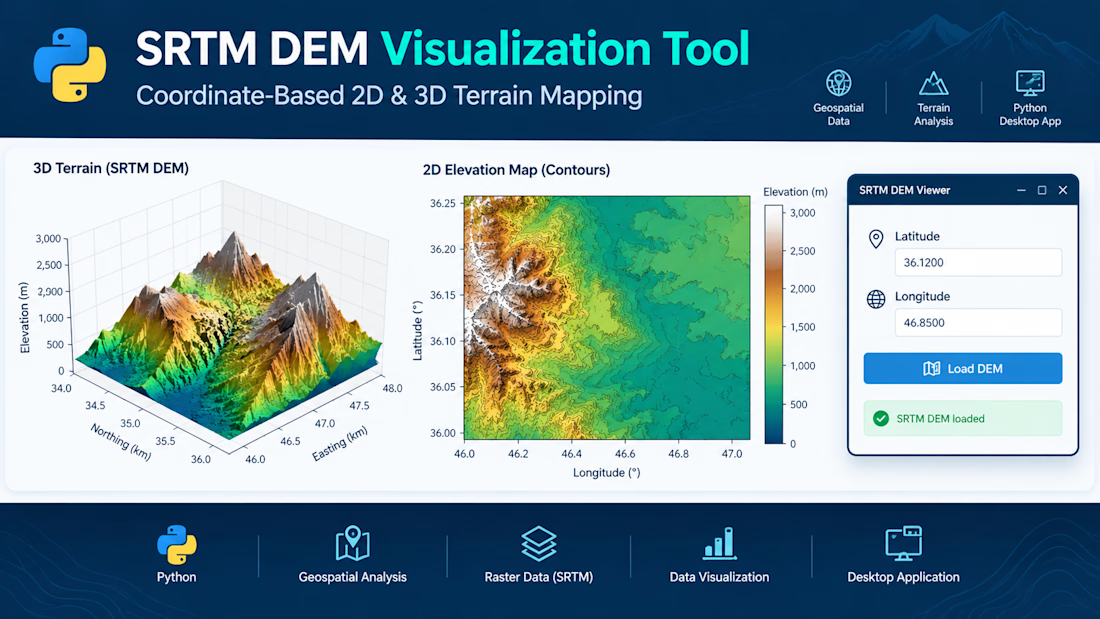
SRTM DEM Visualization Tool – Python Desktop Application
Developed a Python-based desktop application for visualizing Shuttle Radar Topography Mission (SRTM) Digital Elevation Model (DEM) data. The application allows users to enter geographic coordinates (latitude and longitude), load the corresponding elevation data, and explore terrain through interactive 2D and 3D visualizations.
The tool presents a 3D terrain surface to examine landscape features and a 2D elevation map with contour details and elevation-based color mapping. It combines geospatial data processing, raster analysis, and scientific visualization within a user-friendly graphical interface.
Key Features:
- Coordinate-based terrain data selection
- 2D elevation mapping and contour visualization
- 3D terrain surface plotting
- Elevation-based color mapping
- Desktop GUI for convenient data exploration
Technologies: Python, SRTM DEM, geospatial data processing, Matplotlib, 2D/3D visualization, and GUI development.


The network for creativity
Join 1.25M professional creatives like you
Connect with clients, get discovered, and run your business 100% commission-free
Creatives on Contra have earned over $150M and we are just getting started
Related posts


Check it out
New case study live!! 🚀
Forsite brings together aerial LiDAR, pipeline patrol, wildfire science, and professional forestry under one roof, giving operators across North America a single, credentialed partner for the complete intelligence picture their decisions depend on.


The deep green with the phone mockups on stone looks great. Nice case study.

AETHEL — THE SOLSTICE ENGINE
A celestial timepiece transforms into a 15-tier sapphire evergreen—reimagining seasonal luxury through haute horlogerie, architectural scale and procedural visual storytelling. A distinctive fusion of engineering, material science and cinematic imagination, challenging conventional holiday aesthetics.


Excel Data Entry & Data Cleaning Specialist | Microsoft Excel #dataentry #datacleaning #dataformeting #299