Projects using Mapbox in Lahore
Projects using Mapbox in Lahore
Sign Up
Post a job
Sign Up
Log In
Filters
2
Projects
People
Message
5
Toolshed (Data, Automation, AI Agents, Buildship, Framer)
max
Nivio Optimize Route Planning Tool Development
5
30
Message
2
Sharjeel Mansha
pro
𝐀𝐈-𝐏𝐨𝐰𝐞𝐫𝐞𝐝 𝐑𝐞𝐚𝐥-𝐓𝐢𝐦𝐞 𝐀𝐧𝐚𝐥𝐲𝐭𝐢𝐜𝐬 & 𝐃𝐞𝐜𝐢𝐬𝐢𝐨𝐧 𝐈𝐧𝐭𝐞𝐫𝐟𝐚𝐜𝐞 I designed a modern real-time analytics platform focused on making live data easier to understand, explore, and act on. Instead of simply refreshing dashboards, the experience combines interactive visualizations, AI-assisted insights, natural-language queries, and responsive data panels so users can understand what is changing and why it matters. The interface includes dynamic dashboards, live metrics, geographic insights, trend visualizations, AI recommendations, and conversational data exploration, all within a clean, focused user experience. 𝐊𝐞𝐲 𝐅𝐞𝐚𝐭𝐮𝐫𝐞𝐬: • Real-time dashboards and live metrics • AI-powered recommendations and insights • Natural-language data queries • Interactive charts, maps, and visualizations • Context-aware responses based on changing data • Clean visual hierarchy for complex information • Responsive and fluid interface interactions The goal was simple: turn fast-moving data into a clear, intelligent, and actionable experience rather than just another dashboard full of numbers.
1
2
243
Message
3
Sadam Ashraf
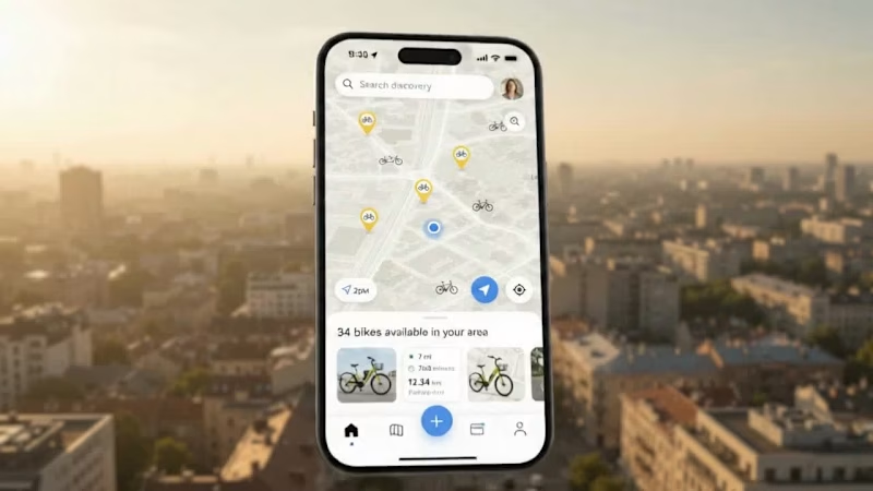
𝐖𝐡𝐚𝐭 𝐢𝐟 𝐟𝐢𝐧𝐝𝐢𝐧𝐠, 𝐮𝐧𝐥𝐨𝐜𝐤𝐢𝐧𝐠, 𝐧𝐚𝐯𝐢𝐠𝐚𝐭𝐢𝐧𝐠, 𝐚𝐧𝐝 𝐭𝐫𝐚𝐜𝐤𝐢𝐧𝐠 𝐚𝐧 𝐞-𝐛𝐢𝐤𝐞 𝐜𝐨𝐮𝐥𝐝 𝐚𝐥𝐥 𝐡𝐚𝐩𝐩𝐞𝐧 𝐭𝐡𝐫𝐨𝐮𝐠𝐡 𝐨𝐧𝐞 𝐬𝐞𝐚𝐦𝐥𝐞𝐬𝐬 𝐞𝐱𝐩𝐞𝐫𝐢𝐞𝐧𝐜𝐞? I designed a modern smart e-bike mobility platform that brings the complete ride journey into one connected product across mobile and web. Users can discover nearby bikes, check availability and condition, monitor battery health, follow live navigation, track ride performance, and review previous journeys through a clean and intuitive interface. The focus was to make a data-rich mobility product feel simple, visual, and effortless for the rider while keeping the experience scalable across both mobile and desktop. Key Features Nearby bike discovery Real-time map navigation Bike availability & condition status Battery health monitoring Ride distance, speed & time analytics Journey history Desktop mobility dashboard Responsive web experience Tools & Technologies Figma · React · Next.js · Tailwind CSS · Mapbox · REST APIs · Node.js · PostgreSQL · Framer Motion · WebSockets · Responsive Web Design Skills UI/UX Design · Product Design · Frontend Development · Dashboard Design · Mobile App Design · Interaction Design · Web Application Development
2
3
252
Message
1
Muzammal Hussain
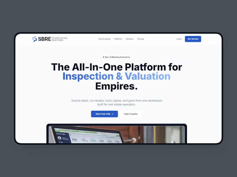
SBRE Connect — Scalable Home-Services Marketplace Platform
1
2
Message
0
Muhammad Ahsan
𝐋𝐨𝐥𝐨 – 𝐓𝐞𝐜𝐡𝐧𝐢𝐜𝐚𝐥 𝐚𝐧𝐝 𝐅𝐮𝐧𝐜𝐭𝐢𝐨𝐧𝐚𝐥 𝐎𝐯𝐞𝐫𝐯𝐢𝐞𝐰 Lolo is a location-based discovery platform built to connect users with nearby services, businesses, and community events. The platform combines an interactive map, visual feed, business profiles, and live local activity to create a real-time local exploration experience. 𝐊𝐞𝐲 𝐅𝐞𝐚𝐭𝐮𝐫𝐞𝐬 𝐋𝐨𝐜𝐚𝐭𝐢𝐨𝐧-𝐁𝐚𝐬𝐞𝐝 𝐃𝐢𝐬𝐜𝐨𝐯𝐞𝐫𝐲 Users can find nearby services, businesses, and events instantly based on their current location for a truly local experience. 𝐈𝐧𝐭𝐞𝐫𝐚𝐜𝐭𝐢𝐯𝐞 𝐌𝐚𝐩 𝐄𝐱𝐩𝐞𝐫𝐢𝐞𝐧𝐜𝐞 A visual map interface allows users to explore local places and activities in real time with intuitive and engaging navigation. 𝐁𝐮𝐬𝐢𝐧𝐞𝐬𝐬 𝐏𝐫𝐨𝐟𝐢𝐥𝐞𝐬 Detailed business listings include key information, media, and engagement details to help users make informed local decisions. 𝐋𝐢𝐯𝐞 𝐋𝐨𝐜𝐚𝐥 𝐀𝐜𝐭𝐢𝐯𝐢𝐭𝐲 𝐅𝐞𝐞𝐝 Real-time updates on what is happening around the user keep the discovery experience fresh, relevant, and always current. 𝐂𝐫𝐨𝐬𝐬-𝐏𝐥𝐚𝐭𝐟𝐨𝐫𝐦 𝐌𝐨𝐛𝐢𝐥𝐞 𝐀𝐜𝐜𝐞𝐬𝐬 A seamless and consistent experience is delivered across both iOS and Android devices without compromise. 𝐂𝐨𝐦𝐦𝐮𝐧𝐢𝐭𝐲 𝐄𝐧𝐠𝐚𝐠𝐞𝐦𝐞𝐧𝐭 𝐋𝐚𝐲𝐞𝐫 Users can discover and interact with local community-driven content, fostering genuine connection with their surrounding area. 𝐓𝐞𝐜𝐡 𝐒𝐭𝐚𝐜𝐤 𝐎𝐯𝐞𝐫𝐯𝐢𝐞𝐰 𝐁𝐚𝐜𝐤𝐞𝐧𝐝 𝐀𝐏𝐈 Node.js with Express powers all core platform logic, data handling, and service integrations reliably and at scale. 𝐃𝐚𝐭𝐚𝐛𝐚𝐬𝐞 𝐚𝐧𝐝 𝐒𝐭𝐨𝐫𝐚𝐠𝐞 PostgreSQL manages all structured relational data including users, businesses, locations, and activity logs with efficiency and precision. 𝐌𝐨𝐛𝐢𝐥𝐞 𝐀𝐩𝐩𝐥𝐢𝐜𝐚𝐭𝐢𝐨𝐧 A React Native-based cross-platform app supports both iOS and Android through a single unified codebase for streamlined development and consistency. 𝐔𝐈 𝐋𝐚𝐲𝐞𝐫 An interactive map, feed-based discovery interface, and business profile screens combine to create a seamless and engaging user exploration experience. 𝐌𝐞𝐝𝐢𝐚 𝐒𝐭𝐨𝐫𝐚𝐠𝐞 AWS S3 or Firebase Storage handles all images, business media, and user-generated content securely and at scale. 𝐂𝐨𝐧𝐭𝐞𝐧𝐭 𝐃𝐞𝐥𝐢𝐯𝐞𝐫𝐲 Optimized media rendering ensures fast loading of visual feeds and business profiles for a smooth and responsive user experience. 𝐒𝐞𝐜𝐮𝐫𝐢𝐭𝐲 𝐚𝐧𝐝 𝐏𝐞𝐫𝐟𝐨𝐫𝐦𝐚𝐧𝐜𝐞 𝐒𝐞𝐜𝐮𝐫𝐞 𝐃𝐚𝐭𝐚 𝐇𝐚𝐧𝐝𝐥𝐢𝐧𝐠 Encrypted communication and secure storage protect all user and business data across every interaction on the platform. 𝐒𝐜𝐚𝐥𝐚𝐛𝐥𝐞 𝐀𝐫𝐜𝐡𝐢𝐭𝐞𝐜𝐭𝐮𝐫𝐞 The backend is designed to support a continuously growing user base and handle real-time location queries without performance degradation. 𝐄𝐟𝐟𝐢𝐜𝐢𝐞𝐧𝐭 𝐃𝐚𝐭𝐚 𝐃𝐞𝐥𝐢𝐯𝐞𝐫𝐲 Optimized APIs ensure fast loading of map data, activity feeds, and business profiles for a consistently smooth experience. 𝐑𝐞𝐥𝐢𝐚𝐛𝐢𝐥𝐢𝐭𝐲 The platform is built for consistent performance across live location-based interactions and real-time updates at all times. 𝐒𝐮𝐦𝐦𝐚𝐫𝐲 Lolo modernizes local discovery by combining real-time location intelligence, interactive mapping, and community-driven content into a single mobile platform. It enables users to seamlessly explore nearby businesses and events while giving businesses a dynamic way to reach local audiences through a unified, scalable, and performance-focused system.
0
73
Message
0
Ameer Hamza
Internet, Phone & TV Service Provider | Frontier.com
0
9
Message
1
Ahmad Mustafa
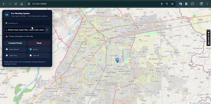
🚗🌍 Can a navigation system recommend the most fuel-efficient route instead of simply the shortest one? This project was developed as part of my MPhil Remote Sensing & GIS thesis. I designed and developed an intelligent Web GIS routing system that generates and compares four alternative routes between an origin and destination and recommends the most suitable route using a Multi-Criteria Decision-Making (MCDM) approach. Instead of considering only distance, the system evaluates multiple factors such as: • 🌱 Fuel-efficiency / environmental suitability • ⏱ Travel duration • 🚧 Road hurdles and route conditions • 📏 Travel distance The alternatives are evaluated using a TOPSIS-based decision model, allowing the system to identify the route with the best overall balance rather than simply choosing the shortest path. I also integrated an AI assistant that explains route recommendations in natural language, helping users understand why one route is preferable to the alternatives. Key features: • Interactive Web GIS navigation • Four-route generation and comparison • MCDM/TOPSIS route ranking • Fuel-efficient route recommendation • Route distance and travel-time analysis • Road-condition / hurdle consideration • AI-generated route explanations • Interactive route visualization • Decision-support interface for sustainable mobility Built with Python, Django, GIS, Leaflet/OpenStreetMap, MCDM and AI integration. This research explores how GIS + decision science + AI can support smarter and more sustainable urban mobility.
1
150
Message
0
Faraz Ahmad
PumpPath - Intelligent Fuel Price & Route Planner
0
73
Message
0
Faizan Aslam
Yesaal
0
7
Message
0
Muhammad Faeez Shabbir
AI-Powered Mission Planner Development
0
5
Message
0
Faraz Ahmad
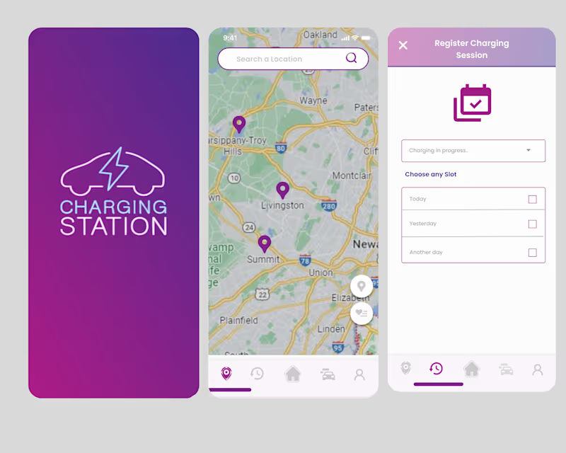
Charging Station- A charging station finding app
0
35
Explore projects