The network for creativity
Join 1.25M professional creatives like you
Connect with clients, get discovered, and run your business 100% commission-free
Creatives on Contra have earned over $150M and we are just getting started
Back to feedPost

I built a database a few months ago to store a few different kinds of spatial datasets. Buildings, roads, land-suitability scores, all for Denver. The pipeline is here: https://lnkd.in/gYWTNFxq
Then I got curious and tried the GeoSQL skill with claude together with Dekart, inspired from Volodymyr Bilonenkor. The idea is that you describe the map you want in plain English, and it writes the spatial SQL, checks it, and renders the result.
Here is some of what I made:
Buildings colored by height, then pulled up into a 3D skyline
Buildings that actually fall inside the flood hazard area, 2,084 of them
A land-suitability choropleth across 268k parcels
Tall buildings sitting near a primary road, layered over the road network and flood zones
What I liked most is that it checks its own work. Row counts, areas, coordinate systems, all validated in SQL before anything gets drawn. So I actually trust the map.
If you do any GIS work, it is worth a look.
The network for creativity
Join 1.25M professional creatives like you
Connect with clients, get discovered, and run your business 100% commission-free
Creatives on Contra have earned over $150M and we are just getting started







Related posts

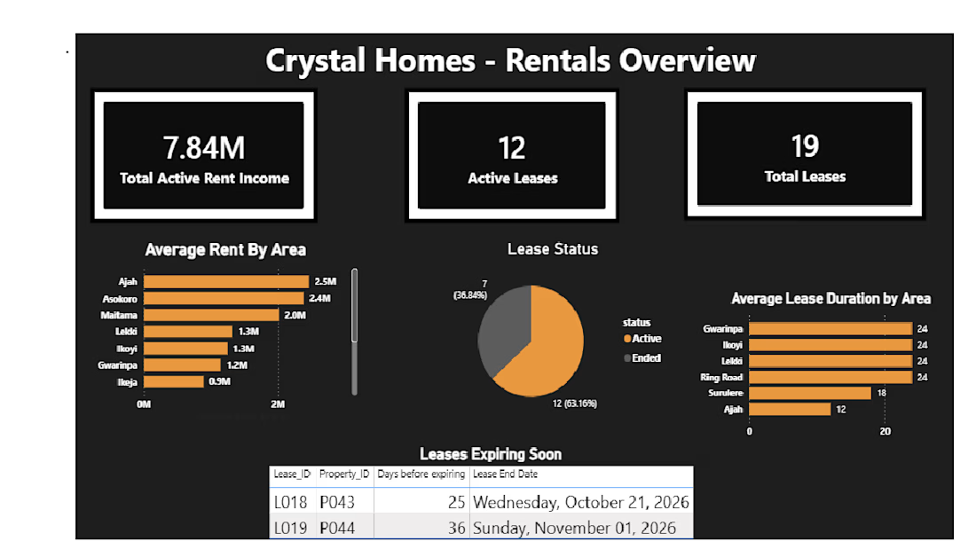
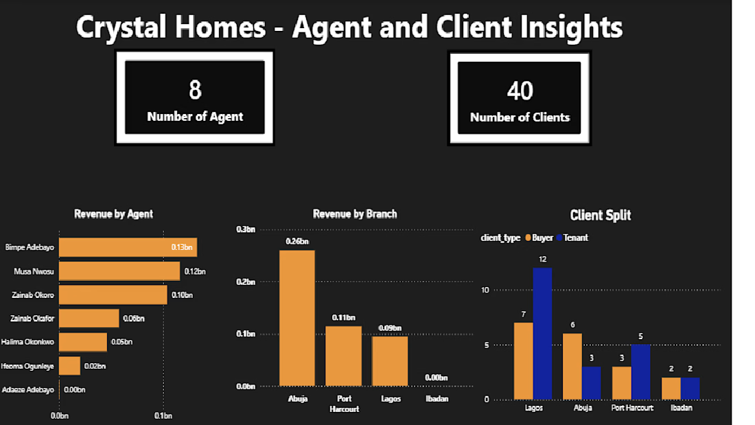
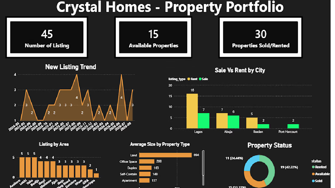
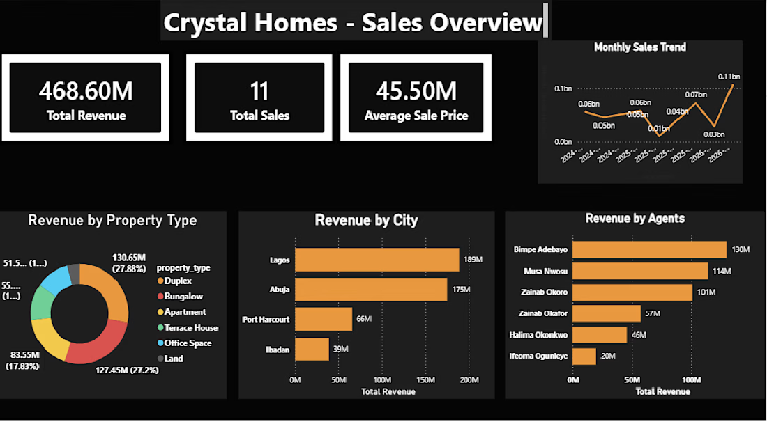
Crystal Homes: Real Estate Sales and Rental Analytics Dashboard
End-to-end analytics project for a fictional Nigerian real estate agency. Raw data from Google Sheets went into MySQL, where I built 21 SQL views, then into a 4-page Power BI dashboard covering sales performance, active rental income, lease expiry tracking, portfolio health, and agent/branch performance. It surfaced findings like ₦468M in tracked revenue and cross-branch sales attribution.
Tools: MySQL, Power BI, SQL, Google Sheets



Designed an academic presentation on GIS-based deforestation mapping using NDVI and satellite imagery. The presentation explains indices-based classification, the use of Landsat data, NDVI calculation, vegetation classification, and land-cover changes between 2002 and 2013 in Hazara District, Pakistan. I organized the technical information into a clear visual flow using maps, comparison tables, charts, step-by-step process slides, and practical applications to make a complex remote-sensing topic easy to understand.


Skaffa Mäklare is a modern real estate comparison platform built for the Swedish housing market, designed to simplify the process of finding and comparing real estate agents. The platform helps homeowners request free property valuations, compare offers from multiple local agents, and make informed decisions based on reviews, expertise, and availability.