The network for creativity
Join 1.25M professional creatives like you
Connect with clients, get discovered, and run your business 100% commission-free
Creatives on Contra have earned over $150M and we are just getting started
Back to feedPost

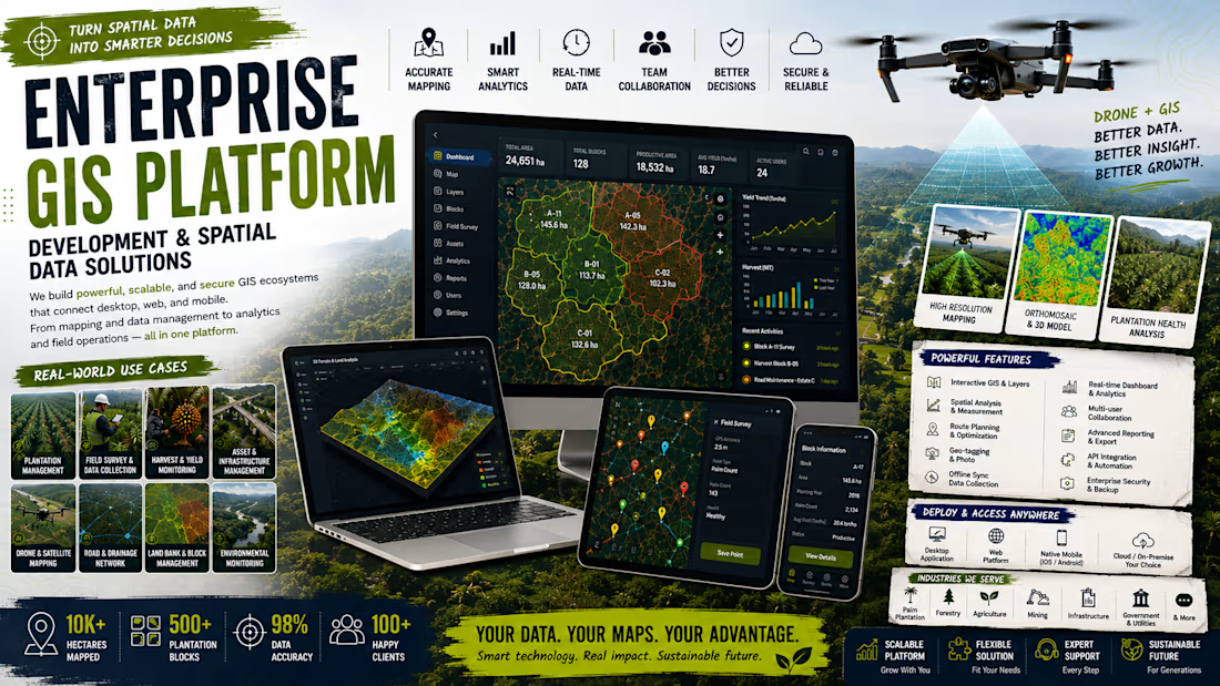
Build Your Enterprise GIS Ecosystem
Modern organizations rely on spatial data to manage assets, infrastructure, plantations, utilities, logistics, field operations, and environmental monitoring. However, disconnected spreadsheets, static maps, and isolated software often make geographic information difficult to maintain, analyze, and share across teams.
This service helps organizations build a complete Enterprise GIS Ecosystem that centralizes spatial data, connects business systems, and transforms geographic information into a unified platform for planning, monitoring, analytics, and operational decision-making.
Rather than delivering a simple web map, I develop scalable GIS platforms that integrate mapping, databases, automation, dashboards, and enterprise applications into one connected ecosystem.
Enterprise GIS Solutions
✓ Enterprise GIS Platform
✓ Interactive Web GIS
✓ Asset & Infrastructure Management
✓ Oil Palm Plantation Management
✓ Smart City Dashboard
✓ Utility & Network Mapping
✓ Environmental Monitoring
✓ Land Parcel & Cadastral Systems
✓ Route Planning & Logistics
✓ Survey & Field Data Collection
✓ Real-Time Asset Tracking
✓ Spatial Analytics Dashboard
✓ Decision Support Systems
✓ Executive Monitoring Dashboard
Core GIS Capabilities
✓ Interactive Maps
✓ Multi-Layer Spatial Visualization
✓ GPS & Mobile Data Collection
✓ Spatial Search & Filtering
✓ Route Optimization
✓ Geofencing
✓ Raster & Vector Processing
✓ Satellite & Drone Imagery Integration
✓ Dashboard & Reporting
✓ Offline Field Mapping
✓ Business Intelligence Integration
Technology Stack
GIS
✓ PostGIS • GeoServer • MapServer • Leaflet • OpenLayers • MapLibre GL
Backend
✓ Go (Golang) • Node.js • Laravel • REST API
Frontend
✓ React • Next.js • TypeScript
Database
✓ PostgreSQL/PostGIS • MySQL
Infrastructure & Integration
✓ Docker • VPS • Cloud Deployment • ERP • CRM • REST API • IoT • GPS • Drone Mapping • Mobile Apps • AI Workflow Automation
Technology is selected according to project requirements, data volume, performance targets, and long-term scalability.
Development Process
Every project follows a structured engineering workflow.
1. Business Discovery
• Identify operational workflows, GIS requirements, datasets, and project objectives.
2. Spatial Data Analysis
• Review map layers, coordinate systems, data quality, and integration requirements.
3. System Architecture
• Design databases, APIs, GIS services, user permissions, and deployment strategy.
4. Development
• Build mapping interfaces, spatial databases, dashboards, and business integrations.
5. Testing & Deployment
• Validate functionality, performance, security, and spatial accuracy before production deployment with complete technical documentation.
Project duration depends on mapping complexity, available datasets, and integration scope.
Deliverables Included
✓ Complete Source Code
✓ GIS Database Structure
✓ API Documentation
✓ Technical Documentation
✓ Deployment Guide
✓ Knowledge Transfer
✓ Production Deployment Assistance
Why Choose This Service?
✓ Custom Enterprise GIS Platform
✓ Modern Spatial Architecture
✓ Interactive Web Mapping
✓ Scalable GIS Infrastructure
✓ API & Business System Integration
✓ Complete Technical Documentation
✓ Production-Ready Deployment
✓ Future-Ready Architecture
Perfect For
✓ Oil Palm Plantation
✓ Agriculture & Forestry
✓ Mining
✓ Government
✓ Smart City
✓ Utilities
✓ Construction
✓ Logistics
✓ Environmental Organizations
Transform Spatial Data Into Business Intelligence
Location data becomes far more valuable when it is connected to everyday business operations. By combining enterprise GIS, spatial databases, automation, and modern software engineering, I help organizations build platforms that improve visibility, accelerate decision-making, and support long-term digital transformation.
Build Your Enterprise GIS Ecosystem — Transforming Spatial Data into Smarter Business Decisions.


The network for creativity
Join 1.25M professional creatives like you
Connect with clients, get discovered, and run your business 100% commission-free
Creatives on Contra have earned over $150M and we are just getting started





Related posts


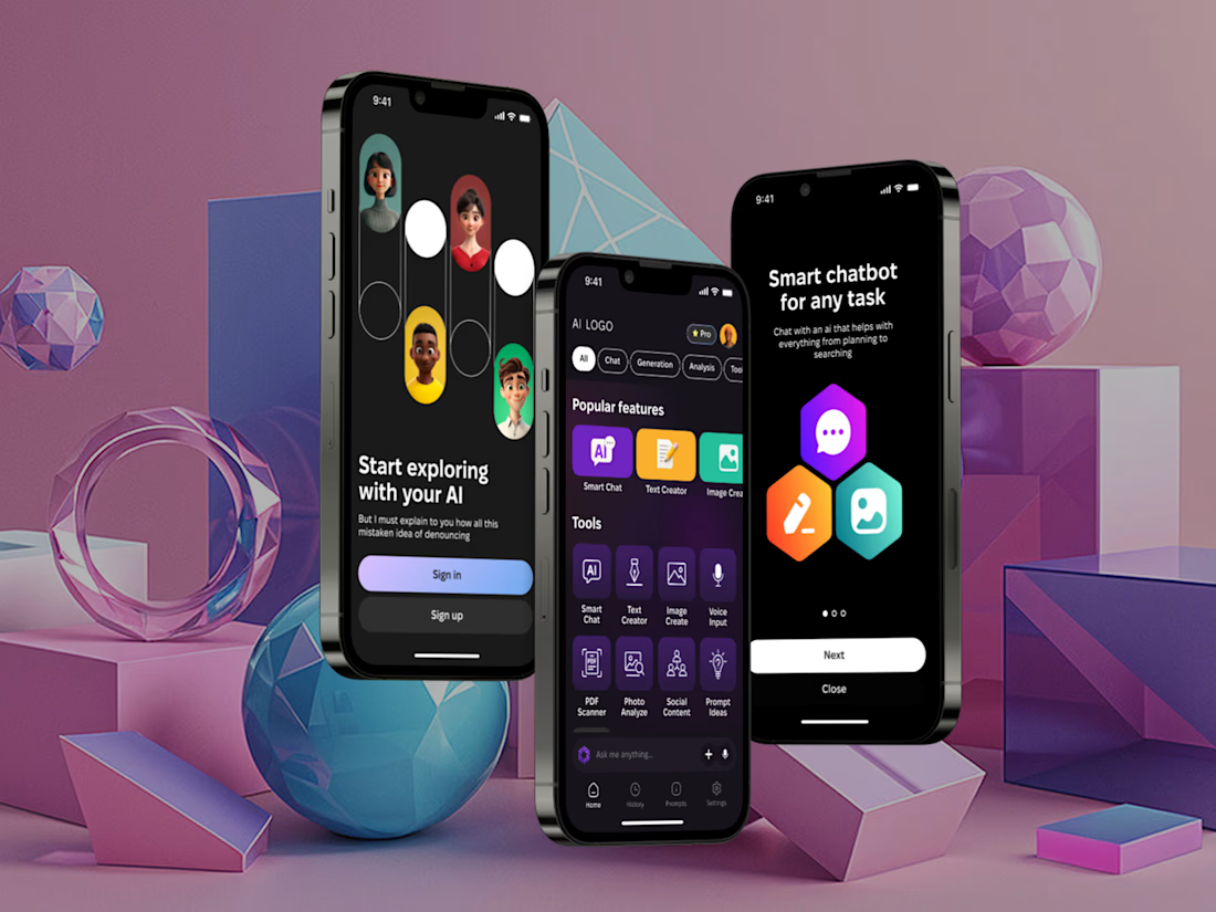
I've built a new mobile AI assistant that brings chat, text and image generation, voice input and document analysis into one app.
It have Smart Chat, Text Creator, Image Create, Voice Input, plus PDF Scanner, Photo Analyze, Social Content and Prompt Ideas, filtered by category.
Almost everything AI can do, just in one place.


Such an amazing tool! Keep going!

Visit the live app here: https://paws-and-puddle-pro.lovable.app/
Meet Sam. He runs a highly requested mobile pet grooming van in Denver, but standard booking calendars are quietly killing his margins. Because generic apps let customers pick any time slot they want, Sam spends two to three hours a day zig-zagging across the city in traffic, burning fuel and losing out on actual appointments just to accommodate a messy schedule.
To fix this, I built Paws & Puddle, a web app that solves his geographic routing nightmare before a booking ever hits the calendar. Instead of a basic form, I engineered a zero-click geo-gate. It automatically fetches a user's zip code via location services and dynamically filters the calendar to only show availability for the specific days Sam’s van is already assigned to their neighborhood.
Because forced logins instantly kill conversion rates, I designed a completely frictionless guest checkout. But to ensure long-term retention, the Thank You page features a "Guest-to-Auth" funnel that seamlessly converts their inputted data into an account post-booking, simply by asking the user to "set a password to track your van's ETA."
Backed by a full operator console where Sam can manage custom service zones, assign route days, and trigger automated status emails, this build proves that premium, minimalist design and aggressive problem-solving belong in the exact same app.
Check out the demo video below to see the end-to-end flow in action! @Lovable #lovablechallenge


Very nice visual design. I love the dog drawings 😍

🚨 What if your business could manage SMS, WhatsApp, Email, users, and messaging gateways from ONE dashboard?
Not 5 different tools.
Not endless switching between platforms.
Not a messy communication workflow.
I built a centralized Business Messaging Platform designed to bring business communication and user management under one roof. 🚀
Instead of building just another admin dashboard, I focused on a real business problem:
Too many communication channels. Too many disconnected tools. Too much manual work.
So I built a system where businesses can:
💬 Manage SMS, WhatsApp & Email communication
👥 Control users, roles & permissions
📧 Create and manage email communication workflows
⚙️ Configure multiple messaging/API gateways
📊 Monitor messaging statistics from one dashboard
🔐 Protect operations with authentication & RBAC
🔌 Connect external services through REST APIs
⚡ Scale the platform as communication volume grows
Under the Hood
Laravel → Secure & scalable backend
React.js → Fast, responsive dashboards
MySQL → Structured data management
REST APIs → Integration-ready architecture
RBAC → Secure user & permission management
API Integrations → Messaging gateways & external services
But the important part isn't the tech stack.
It's what the technology can remove from a business.
Less platform switching.
Less repetitive communication work.
Less fragmented user management.
And one centralized system built around the company's actual workflow.
💡 That’s the kind of software I like building — not just websites, but systems that solve expensive business problems.
If your company is still managing customers, messaging, internal workflows, or integrations across disconnected tools, there may be a much better way to build it.
📩 Need a custom SaaS platform, business dashboard, messaging system, API integration, or automation solution? Let’s build it.
#LaravelDeveloper #FullStackDeveloper #ReactDeveloper #PHPDeveloper #SaaSDevelopment #WebApplicationDevelopment #BusinessAutomation #WorkflowAutomation #APIIntegration #RESTAPI #WhatsAppAPI #SMSAPI #EmailAutomation #AdminDashboard #CustomSoftwareDevelopment #BackendDevelopment #MySQL #Laravel #ReactJS #SaaS #BusinessSoftware


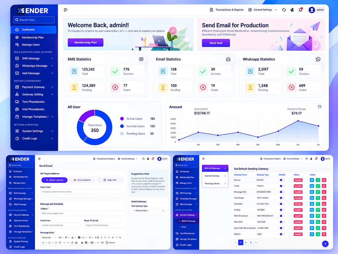

Seeing the single pane for SMS, WhatsApp and email cuts the back and forth you'd otherwise spend juggling tools.