The network for creativity
Join 1.25M professional creatives like you
Connect with clients, get discovered, and run your business 100% commission-free
Creatives on Contra have earned over $150M and we are just getting started
Back to feedPost

Homepage Exploration for Travel Spree App.
Which Icon set do you prefer? Left or right?

The network for creativity
Join 1.25M professional creatives like you
Connect with clients, get discovered, and run your business 100% commission-free
Creatives on Contra have earned over $150M and we are just getting started











Related posts

Planning a beach day shouldn’t mean checking five different apps and hoping they agree.
That’s the problem behind CoastCheck, a map based app for comparing beach conditions before choosing where to go.
I started with the map because beaches are all about place. You can search for a beach, explore what’s nearby, or browse a catalog with more than 57,000 location records. Wave height markers put one useful condition directly on the map, so you can scan the coast before opening a beach card. Map styles include satellite, topographic, street, daylight, and dark vector.
Tap a beach and the details come together in one place: wave height and period, air and sea temperature, wind, UV, rain chance, nearby beaches, and a photo with its attribution. Forecasts show their model and retrieval times. If tide data isn’t available for a location, CoastCheck says so. I wanted the interface to be useful without pretending the data is more certain than it is.
From there, I built out the rest of the planning flow. You can compare beaches, save favorites, make lists, revisit recently viewed places, and share a beach with friends or family. Directions include different travel modes, estimated trip times, and step by step routes. The profile keeps saved places and preferences together, including beaches saved in the browser before signing in.
A lot of the work was in making the details feel like one product: the map markers, glass panels, beach cards, forecast views, search, and navigation all need to support the same decision. Where should we go, and what can we expect when we get there?
CoastCheck uses modeled weather and marine forecasts, not sensor readings. Conditions can change, so the goal is to give people a better starting point for planning, not a guarantee of beach safety.
This build also showed me that Base44 is more than a way to make websites. It can bring together maps, data, and interactive workflows in a web app built around a real everyday problem.
CoastCheck: https://coastcheck.base44.app/
#Base44Challenge @Base44


Check it out this my project out and give your feedback. I will appreciate you.


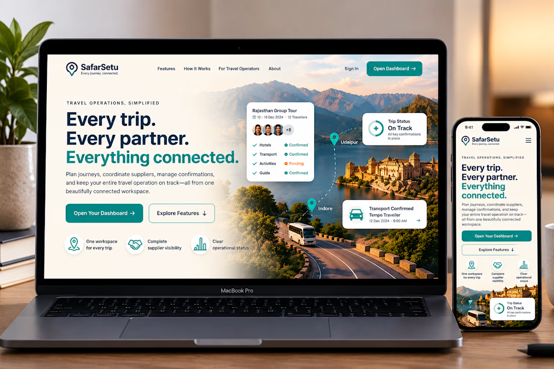
SafarSetu — Travel Tech Website Concept
Every journey. Every partner. Everything connected.
SafarSetu is a travel operations platform concept designed to help travel operators coordinate trips, manage supplier confirmations, and keep every moving part connected in one workspace.
For this concept, I explored a premium, modern visual direction that combines immersive travel photography with a clean SaaS interface. The hero section brings together the brand story, key product benefits, and a clear path into the dashboard.
Design highlights
A modern, responsive website hero for desktop and mobile
A refined colour palette of warm ivory, deep navy, and teal
Cinematic travel imagery inspired by India's landscapes
Floating UI cards showcasing trip status and booking confirmations
Clear calls to action and a consistent visual hierarchy
The goal was to bridge the emotion of travel with the clarity of a professional operations tool.
Project type: Website UI/UX concept
Focus: Visual design, responsive layouts, brand direction, and product storytelling
Status: Design concept and mockup
#WebDesign #UIDesign #UXDesign #SaaSDesign #TravelTech


Love how you’ve combined the beauty of travel with a clean, practical design! The floating dashboard cards are a nice touch. Great concept! 👏✨