The network for creativity
Join 1.25M professional creatives like you
Connect with clients, get discovered, and run your business 100% commission-free
Creatives on Contra have earned over $150M and we are just getting started
Back to feedPost

Can satellite machine learning tell a felled forest from a harvested field? 🛰️
At 10 metres, the answer is: only if your feature stack and your validation are built for it.
Most land-cover maps break at exactly this problem — forest loss and agricultural cycles look similar in a single image. So I built an end-to-end GeoAI system that separates them properly, from raw Sentinel-2 telemetry to an interactive cloud-native app on Google Earth Engine.
How the pipeline was engineered:
🔹 Data ingestion & atmospheric preprocessing
Harmonized Sentinel-2 Level-2A surface reflectance (10–20m) across multi-temporal epochs (2017 vs 2023), with rule-based cloud and shadow masking using the Scene Classification Layer (SCL).
🔹 Multi-spectral feature engineering
Beyond standard VNIR bands, a 10-dimensional feature stack — NDVI (canopy vigor), MNDWI (hydrological discrimination), NDMI (canopy moisture, B8 + B11), NBR (disturbance sensitivity, SWIR-2 B12).
🔹 Supervised ML & validation
100-tree Smile Random Forest with stratified random sampling referenced to ESA WorldCover v200. Performance reported through confusion matrices, Overall Accuracy, and Cohen's Kappa — not just a pretty map.
🔹 Interactive split-map deployment
A synchronized ui.SplitPanel with a docked analytics dashboard, live class legends, and non-blocking client-side statistics via evaluate() — stakeholders can explore change without touching GIS software.
Why this matters to the people who need it:
Conservation and REDD+ teams need defensible deforestation evidence. Urban planners need land-use change they can rerun. Agri-tech and environmental consultancies need a reproducible baseline fast. That's who this workflow is built for — and why every deliverable ships with a methodology report and a rerunnable script, not a dead static PDF.
Working on land-cover change, forest monitoring, or LULC classification in GEE? Send me your area of interest and time range — I'll tell you within 24 hours whether Sentinel-2 can answer your question, and what the workflow would involve.


The network for creativity
Join 1.25M professional creatives like you
Connect with clients, get discovered, and run your business 100% commission-free
Creatives on Contra have earned over $150M and we are just getting started
Related posts

Such a neat experiment in AI-assisted spatial design! Using 10 photos of a real setup to train a local model like FLUX 3 Klein is next-level prototyping.
Both options look great, but Option A totally wins on the cozy lighting front for me. Check out the post and drop your vote


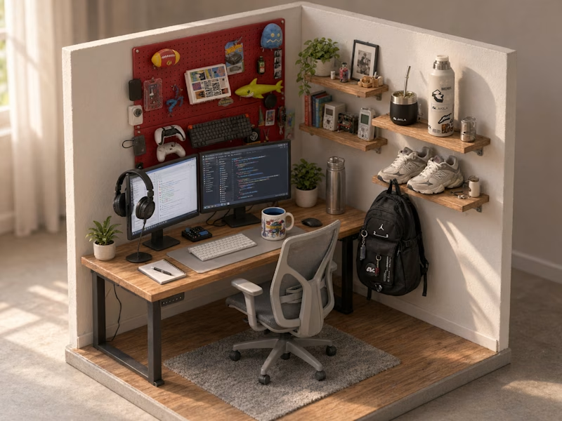
Turned my real desk into a tiny clay diorama ☕️
Made with FLUX 3 Klein running locally, using 10 photos of my actual setup as references: the pegboard wall, headphones, mug, shelves...
Which one do you like more, A or B?
21 voted
58%

15 voted
42%
36 votes
Closed

This is insane! Option A is my favorite - the details are so realistic!
Love how you turned your real setup into clay with FLUX 3 locally, super creative idea!

Proud to officially add the AWS Certified Machine Learning Engineer - Associate certification to my toolkit!
Building robust machine learning pipelines and scaling AI workloads securely on the cloud has always been a key focus of mine. Earning this certification has been a great deep-dive into mastering AWS ML infrastructure, MLOps best practices, and production-grade architectures.
Ready to bring these advanced capabilities to upcoming data science and engineering projects! Let's build something impactful. 💡💪
🔗 Verify Certificate:
Validation Number: 74c5808986a64b84addcaa9db725b8bd
Verification Link: https://aws.amazon.com/verification
#AWS #MachineLearning #AI #CloudComputing #DataAnalysis #MLOps




Congratulations on earning the AWS Machine Learning Engineer certification, Hazem khaled! Robust pipelines and cloud automation make all the difference for production-grade AI systems.

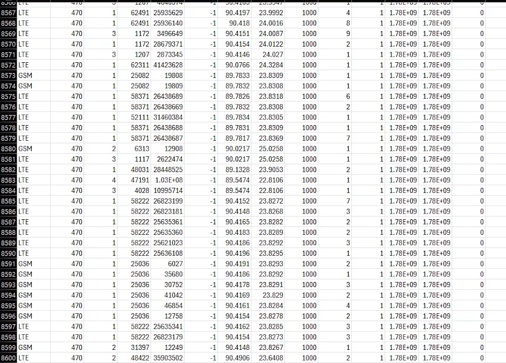
An infrastructure intelligence platform built on 8,600 verified Bangladeshi network cell towers to locate emergency callers without GPS, identify shared tower opportunities, analyze highway connectivity, and run in-browser diagnostics.
Project Overview:
The most precious thing we own is our life. While many developed countries have put their name in the absolute pinnacle of tech industry. Developing and under Developing countries suffer a massive issue due to lack in advancements in tech. People, women, kids suffer from natural disasters and Monsoon floods regularly isolate families in districts in Bangladesh such as Sylhet, Sunamganj, and Feni. Most residents in affected rural areas rely on basic feature phones rather than smartphones with active GPS or mobile data. When calling emergency lines, they cannot share a digital map pin. However, their phone diagnostic screen displays their serving base station codes: the Location Area Code and Cell Identifier.
At the same time, mobile network operators frequently duplicate infrastructure by erecting towers within walking distance of each other, incurring redundant land leases and diesel generator costs. Freight and cold-chain logistics fleets also face coverage dropouts along major trade routes because dispatchers lack route-specific carrier performance data.
KUTNI MCC470 addresses these operational problems using a verified dataset of 8,600 physical cell towers across Bangladesh (MCC 470). It does not use simulated points, mock coordinates, or placeholder records. Every calculation runs on confirmed base stations belonging to Grameenphone, Robi, Banglalink, and TeleTalk.
It's not just a sci-fi concept, this platform not only helps in saving someone's life, but also plays a crucial role in Startups. (From a person getting saved from a life threatening disaster to a Real Estate company using this feature to give their customer's a bit of unique service by telling them which SIM cards to avoid or use for that specific home, ultimately earn some money-money in their wallets).
Core Platform Capabilities:
1. Interactive 3D Globe Network Map
It renders all 8,600 verified network cell towers present in Bangladesh on a 3D spherical Earth using MapLibre GL. Includes three conjoined map controls:
1. Real-life Satellite: Toggle photorealistic ArcGIS world imagery tiles.
2. 2D to 3D Globe: Toggle spherical Earth projection.
3. Reload and Reset: Recenter camera directly over Bangladesh.
It provides real-time filtering by operator (Grameenphone, Robi, Banglalink, TeleTalk) and radio generation (4G LTE, 3G UMTS, 2G GSM).
2. Emergency Phone Triangulation
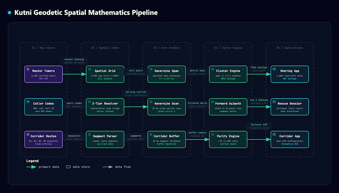
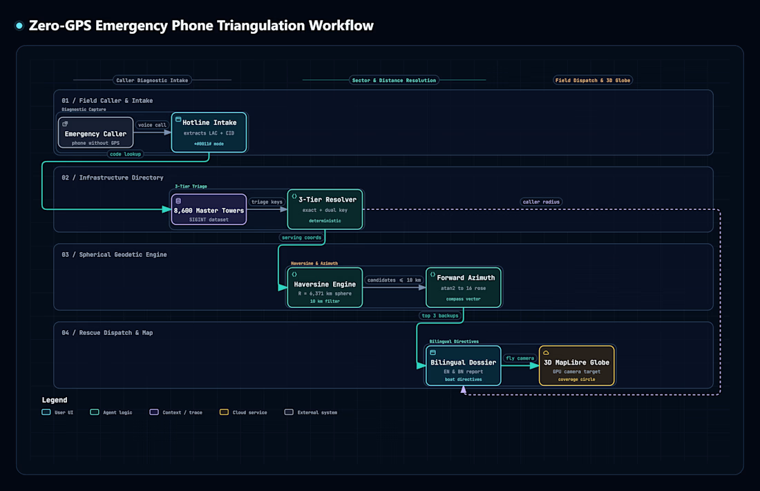
If an emergency caller uses a basic phone during a flood, a rescue volunteer can ask for the tower numbers displayed on their screen (Location Area Code and Cell ID). It matches those codes to the physical mast location and renders an approximate search perimeter and then calculates the three nearest backup towers from alternative carriers within 10 kilometers using the Haversine formula. Ultimately generating a bilingual field dispatch sheet in English and Bengali with compass bearings for boat crews.
3. Tower Sharing and Co-Location Optimizer
By constructing a cell mast requires significant capital, recurring land rent, and diesel generator fuel. It evaluates distances across all 8,600 towers in real time. Later identifies over 1,000 locations where competing carriers built standalone towers within 250 meters of one another and finally computes annual operational savings in Bangladeshi Taka achieved by consolidating onto a shared structure.
4. Highway Transport Corridors
Freight trucks, delivery vans, and emergency vehicles require continuous network reception along trade routes. Kutni inspects a whole bunch of cell tower distribution along primary national arteries: N1 (Dhaka to Chittagong), N2 (Dhaka to Sylhet), N5 (Dhaka to Bogra), and N8 (Dhaka to Khulna via the Padma Bridge). Furthermore it compares 4G LTE high-speed coverage against 2G GSM voice fallback. Finishing off by formulating primary and failover Dual-SIM hardware configurations for vehicle telematics units.
5. Genuine x86 Virtual Machine Sandbox
Kutni integrates a client-side WebAssembly x86 PC emulator running directly in the browser (meaning real life Operating Systems). It boots graphical KolibriOS or lightweight Linux BusyBox for offline diagnostic calculations and field scripts without server dependence.
6. Systems Architecture Dossier and Plain English Guide
Kutni outlines technical specifications, dataset schemas, and architectural credentials. It furthermore provides a step-by-step interactive walkthrough that explains every operational tool clearly.
Design System and Interface:
1. Color Scheme: Deep obsidian foundation (#070c0e), mint phosphor accents (#00d2be), imperial gold highlights (#d4af37), and telecom cyan (#00A8E8).
2. Tactile Surfaces: Glass-morphic panels with metallic borders, high-contrast status readouts, and responsive mobile and desktop viewports.
3. Audio Feedback: Mechanical clicks and tones synthesized using the Web Audio API for tactile operational confirmation.

For those interested in reviewing the project documentation and underlying calculations, the complete repository is available by clicking here.
This folder includes the verified 8600 network tower lists (CSV), the project pipelines/flowcharts, and a detailed PDF containing all mathematical formulas and equations used.