
GIS Mapping, Spatial Analysis & Geospatial AutomationAneeq Abbasi
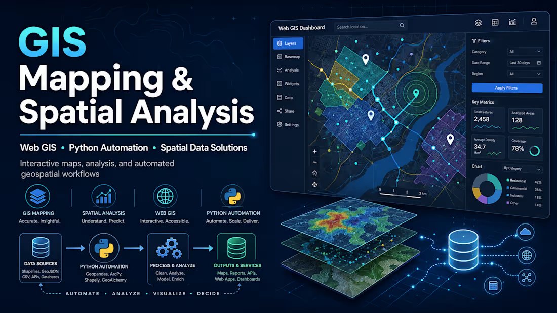
Turn your location data into maps, spatial insights, interactive Web GIS applications, and automated geospatial workflows.
I build GIS solutions that turn location and spatial data into clear maps, actionable insights, interactive web applications, and automated geospatial workflows.
Whether you need a professional map, complex spatial analysis, a Web GIS application, geospatial database, or Python automation, I can build a solution tailored to your data and business requirements.
What I Can Help You With
GIS Mapping & Cartography
Professional thematic and analytical maps
Administrative and operational maps
Site and location maps
Heatmaps and density maps
Choropleth maps
Network and infrastructure maps
Print-ready map layouts
Custom map styling and visualization
Spatial Analysis
Buffer and proximity analysis
Spatial joins
Point-in-polygon analysis
Location and suitability analysis
Service-area analysis
Cluster and hotspot analysis
Distance calculations
Spatial statistics
Territory and coverage analysis
Catchment-area analysis
Web GIS & Interactive Maps
Interactive web maps
Custom Web GIS applications
Map-based dashboards
Location search and filtering
Layer controls
Interactive markers and popups
Spatial-data visualization
Database-connected web maps
Technologies may include:
Leaflet • Folium • Mapbox • OpenStreetMap • ArcGIS Online • JavaScript • Python
GIS Automation with Python
I can automate repetitive GIS processes using Python, including:
Batch geoprocessing
Automated map generation
Spatial-data cleaning
Geocoding workflows
Coordinate processing
Spatial joins and overlays
Automated reporting
File conversion
GIS data pipelines
Large dataset processing
Typical technologies:
Python • GeoPandas • ArcPy • Shapely • GDAL • Pandas
Spatial Databases
I can design and work with spatial databases including:
PostgreSQL / PostGIS
SQL Server spatial data
MySQL spatial databases
Geodatabase design
Spatial SQL queries
Data integration
Data validation and transformation
GIS Data Processing
I can work with:
Shapefile • GeoJSON • KML/KMZ • GeoPackage • CSV • Excel • Raster • GeoTIFF • GPS coordinates • SQL databases • API data
Including:
Data cleaning
Coordinate-system correction
Georeferencing
Data conversion
Attribute management
Geometry validation
Data integration
Deliverables
Depending on the project, you may receive:
GIS project files
Interactive maps
Web GIS application
Spatial analysis results
Python automation scripts
Cleaned geospatial datasets
Spatial database
Maps in PDF/PNG/JPEG
GeoJSON/Shapefile/GeoPackage outputs
Analysis report or documentation
Source code where applicable
Why Work With Me?
I don't only create maps.
I build complete geospatial workflows — from raw spatial data and databases to analysis, automation, visualization, and interactive GIS applications.
My work combines:
GIS + Spatial Analysis + Python + SQL + Databases + Web Mapping + Automation
This means I can help with both a single GIS task and larger end-to-end geospatial solutions.
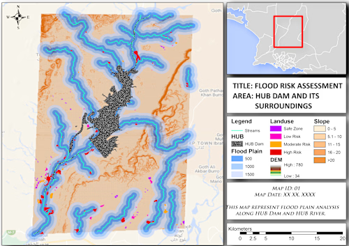
Example work
Contact for pricing
Duration1 week
Tags
ArcGIS

pandas

Python

QGIS

Geospatial
ArcMap
WebGIS
Service provided by
Aneeq Abbasi Karachi, Pakistan
GIS Mapping, Spatial Analysis & Geospatial AutomationAneeq Abbasi
Contact for pricing
Duration1 week
Tags
ArcGIS
pandas
Python
QGIS
Geospatial
ArcMap
WebGIS
Turn your location data into maps, spatial insights, interactive Web GIS applications, and automated geospatial workflows.
I build GIS solutions that turn location and spatial data into clear maps, actionable insights, interactive web applications, and automated geospatial workflows.
Whether you need a professional map, complex spatial analysis, a Web GIS application, geospatial database, or Python automation, I can build a solution tailored to your data and business requirements.
What I Can Help You With
GIS Mapping & Cartography
Professional thematic and analytical maps
Administrative and operational maps
Site and location maps
Heatmaps and density maps
Choropleth maps
Network and infrastructure maps
Print-ready map layouts
Custom map styling and visualization
Spatial Analysis
Buffer and proximity analysis
Spatial joins
Point-in-polygon analysis
Location and suitability analysis
Service-area analysis
Cluster and hotspot analysis
Distance calculations
Spatial statistics
Territory and coverage analysis
Catchment-area analysis
Web GIS & Interactive Maps
Interactive web maps
Custom Web GIS applications
Map-based dashboards
Location search and filtering
Layer controls
Interactive markers and popups
Spatial-data visualization
Database-connected web maps
Technologies may include:
Leaflet • Folium • Mapbox • OpenStreetMap • ArcGIS Online • JavaScript • Python
GIS Automation with Python
I can automate repetitive GIS processes using Python, including:
Batch geoprocessing
Automated map generation
Spatial-data cleaning
Geocoding workflows
Coordinate processing
Spatial joins and overlays
Automated reporting
File conversion
GIS data pipelines
Large dataset processing
Typical technologies:
Python • GeoPandas • ArcPy • Shapely • GDAL • Pandas
Spatial Databases
I can design and work with spatial databases including:
PostgreSQL / PostGIS
SQL Server spatial data
MySQL spatial databases
Geodatabase design
Spatial SQL queries
Data integration
Data validation and transformation
GIS Data Processing
I can work with:
Shapefile • GeoJSON • KML/KMZ • GeoPackage • CSV • Excel • Raster • GeoTIFF • GPS coordinates • SQL databases • API data
Including:
Data cleaning
Coordinate-system correction
Georeferencing
Data conversion
Attribute management
Geometry validation
Data integration
Deliverables
Depending on the project, you may receive:
GIS project files
Interactive maps
Web GIS application
Spatial analysis results
Python automation scripts
Cleaned geospatial datasets
Spatial database
Maps in PDF/PNG/JPEG
GeoJSON/Shapefile/GeoPackage outputs
Analysis report or documentation
Source code where applicable
Why Work With Me?
I don't only create maps.
I build complete geospatial workflows — from raw spatial data and databases to analysis, automation, visualization, and interactive GIS applications.
My work combines:
GIS + Spatial Analysis + Python + SQL + Databases + Web Mapping + Automation
This means I can help with both a single GIS task and larger end-to-end geospatial solutions.
Example work
Contact for pricing